


Cooch Behar - West Bengal
Cooch Behar is regarded as one of the oldest town in the state that is situated in the northeastern part of West Bengal. The district is famous as an agricultural center and has great historical significance as well. It is now a well known tourist destination. It is home for the well known tiger of West Bengal and other animals like Bisons, Rhinocerous etc due to thick forest in the area. During the British rule, the district was a princely state, which was ruled by the Koch dynasty. It is the third least populous district of the state.
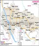
Locations of Cooch Behar
Cooch Behar comes under the Jalpaiguri division and is located in the north eastern part of West Bengal The surrounded districts are Jalpaiguri to the north, Assam state to the east, Bangladesh to the west and the south. It is a significant part of the Himalayan Terai of the state. The total covered is 3,387 square kilometers. The district lies between 25 degree 57'47 "to 26 degree 36'2" north latitude and between 89 degree 54'35" to 88 degree 47'44 "east longitude.
Town and villages
The headquarters is situated in Cooch Behar town and has several important towns and villages in the district. Various places like the Matabhanga, Haldibari, Tufanganj, Sitalkuchi, Sitai, and Dinhata and major towns in the district. Smaller villages like the Uchalpukhari, Natabari Hat, Rampur, Jamaldaha Hat, Baneswar, Balarampur, Bhitagurim Hemkumari, and Khagrabari have good road ways that help to connect to major towns and other districts. There are six rivers that flow across the district namely the Testa, Kaljani, Ghargharia, Torsha, Raidak, Jaldhaka, and Gadadhar. River Torsha flows on the western side of the town.
Transport in Cooch Behar
The district boosts of a good rail and road network. The new Cooch Behar is located around five kilometers from the main town. It is connected to most of the metro cities in the country. The rail route connects north east India with the country. Many express and superfast trains have a stop here. The second railway station namely Cooch Behar is located inside the town, but only a few local trains run on this route. The district also has National Highway No 31 that connects the district within the district as well as outside.
District profile
According to the 2011 census, the population of the district was 2,822,780 and ranked 136th in the country. The literacy rate recorded in 2011 is 75.49 percent. The sex ratio here was 942 females for every 1000 males.
| Facts of Cooch Behar District | |
|---|---|
| State | West Bengal |
| District | Cooch Behar |
| District HQ | Cooch Behar |
| Population (2011) | 2819086 |
| Growth | 13.71% |
| Sex Ratio | 942 |
| Literacy | 74.78 |
| Area (km2) | 3387 |
| Density (/km2) | 833 |
| Tehsils | Cooch Behar I, Cooch Behar II, Dinhata I, Dinhata II, Haldibari, Mathabhanga I, Mathabhanga II, Mekliganj, Sitai, Sitalkuchi, Tufanganj I, Tufanganj II |
| Lok Sabha Constituencies | Coochbehar (Sc), Alipurduars (St), Jalpaiguri (Sc) |
| Assembly Constituencies | Mekliganj, Mathabhanga, Cooch Behar Uttar, Cooch Behar Dakshin, Sitalkuchi, Sitai, Dinhata, Natabari, Tufanganj |
| Languages | Bengali including Assamese, Rajbangsi, Hindi |
| Rivers | Teesta, Jaldhaka, Torsha, Kaljani, Raidak, Gadadhar , Ghargharia |
| Lat-Long | 26.32296,89.317245 |
| Travel Destinations | Rajbari, Madan Mohan Bari, Heritage Buildings, Sagar Dighi, Baradebi Bari, Madhupur Dham Temple, Baneswar Temple, Kamteswari Temple, Siddhanath Siva Temple, Jaldapara Wildlife Sanctuary, Garumara National Park, Chapramari Forest, Buxa Tiger Reserve etc. |
| Government Colleges/Universities | Uttar Banga Krishi Viswa Vidyalaya, Acharjya Brajendra Nath Seal (A.B.N.Seal) College, Baneswar Sarathibala College, Baxirhat College, University B.T. & Evening College, Cooch Behar College, Dewanhat Mahavidyalaya, Dinhata College, Ghoskadanga Birendra Mahavidyalaya, Madhusudan Hore Mahavidyalaya, Mathabhanga College, Mjn Sanskrit College, Mekhliganj College, Netaji Subhas Mahavidyalaya, Sitalkuchi College, Thakur Panchanan Mahila Mahavidyalaya, Tufanganj Mahavidyalaya etc. |