


Hyderabad has served as the combined capital of Andhra Pradesh and Telangana since the state's partition in 2014. Hyderabad is well-known for its rich historical legacy. Anantapur, Chittoor, Guntur, Nellore, Kurnool, and Visakhapatnam are some of the state's well-known districts (which is currently serving as the administrative capital of Andhra Pradesh). However, Amaravati and Kurnool function as the state's legislative and judicial capitals. In a few years, Amravati will be the de facto capital of Andhra Pradesh.
Historical Background
Andhra Pradesh's history dates back to the Vedic times. The ancient literature Aitareya Brahmana mentions it by name. There is evidence that the coastal kingdom of Andhra Pradesh prospered under Satavahana's control. Between the Godavari and Krishna rivers, inland and maritime trade thrived. During the period, the money was utilised to enable barter. There is additional evidence that Buddhism flourished here during the reign of the Ikshvakus of Nagarjunakonda. Despite the monarchs' devotion to Vedic ritualism, Buddhism flourished, as evidenced by the numerous Stupas, Chaityas, and Viharas found here.
The Andhra area was ruled by numerous kingdoms, including the Kakatiya Dynasty, the Reddy Clan, the Vijayanagar Empire, Mughal domination, and, finally, the British Empire in 1792. In 1948, the princely state of Hyderabad became a part of India upon independence. Andhra Pradesh was the very first state to be constituted based on language under the State Reorganisation Act in 1956.
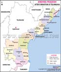
Following that, the Telangana Movement began, and Andhra Pradesh was divided in 2014, giving birth to Telangana as a new state.
Major Attractions
There are several locations to explore in this lovely state. Visakhapatnam is a beautiful beach location with beautiful lakes, valleys, caverns, and hill ranges. The Araku Valley is a well-known hill station with coffee fields and waterfalls. Another well hill town in the state is Horsley Hills. Lake Gangotri, the TU 142 Aircraft Museum, and other attractions are also nearby.
Kolleru Lake, one of India's largest freshwater lakes, is also located in Andhra Pradesh. It is located between the Krishna and the Godavari Deltas. There are also religious and pilgrimage spots, such as Tirupati, which attracts millions of devotees each year. Nellore is also extremely spiritually significant. Vijaywada is well-known for its stunning heritage sites, caves, and hills. Chittor is a farming town famed for its hills, rivers, and forts. Nagari Hills, Horsley Hills, and the Kaundinya Wildlife Sanctuary are all located here.
Kurnool contains various caverns and forts, and the city is surrounded by mountain ranges. Anantapur is well-known for its diamond mining. Thimmamma Marrimanu, the banyan tree, is found in the state and is one of the world's largest tree specimens.
Andhra Pradesh is well-known for its mineral riches. Andhra Pradesh's major sectors include digital technologies, biotech, pharmaceuticals, and real estate. Telugu is the state's official language. The co-official language is Urdu.
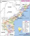
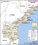
Map of Andhra Pradesh
Andhra Pradesh has 26 districts, as seen on the map. The names of all these districts in Andhra Pradesh, as well as some significant information about them, are given below:
| Name of the District | Headquarter | Population | Area | Density |
|---|---|---|---|---|
| Dr. B.R. Ambedkar Konaseema | Amalapuramu | 17,19,093 | 2083 | 825.3 |
| Anakapalli | Anakapalli | 17,26,998 | 4292 | 402.38 |
| Anantapur | Anantapur | 22,41,105 | 10205 | 219.61 |
| Bapatla | Bapatla | 15,86,918 | 3829 | 414.45 |
| West Godavari | Bhimavaram | 17,79,935 | 2178 | 817.23 |
| Chittoor | Chittoor | 18,72,951 | 6855 | 273.22 |
| Eluru | Eluru | 20,71,700 | 6679 | 310.18 |
| Guntur | Guntur | 20,91,075 | 2443 | 855.95 |
| YSR | Kadapa | 20,60,654 | 11228 | 183.53 |
| Kakinada | Kakinada | 20,92,374 | 3019 | 693.07 |
| Kurnool | Kurnool | 22,71,686 | 7980 | 284.67 |
| Krishna | Machilipatnam | 17,35,079 | 3775 | 459.62 |
| Nandyal | Nandyala | 17,81,777 | 9682 | 184.03 |
| Palnadu | Narasaraopeta | 20,41,723 | 7298 | 279.76 |
| Sri Potti Sriramulu Nellore | Nellore | 24,69,712 | 10441 | 236.54 |
| Prakasam | Ongole | 22,88,026 | 14322 | 159.76 |
| Alluri Sitharama Raju | Paderu | 9,53,960 | 12251 | 77.87 |
| Parvathipuram Manyam | Parvathipuram | 9,25,340 | 3659 | 252.89 |
| Sri Sathya Sai | Puttaparthi | 18,40,043 | 8925 | 206.17 |
| East Godavari | Rajahmahendravaram | 18,32,332 | 2561 | 715.48 |
| Annamayya | Rayachoti | 16,97,308 | 7954 | 213.39 |
| Srikakulam | Srikakulam | 21,91,471 | 4591 | 477.34 |
| Tirupati | Tirupati | 21,96,984 | 8231 | 266.92 |
| NTR | Vijayawada | 22,18,591 | 3316 | 669.06 |
| Visakhapatnam | Visakhapatnam | 19,59,544 | 1048 | 1869.79 |
| Vizianagaram | Vizianagaram | 19,30,811 | 4122 | 468.42 |
Major Attractions
- Capital of the state: Amravati
- Date of Formation: 1st Nov 1956
- Governor: Syed Abdul Nazeer
- Chief Minister: Sri Nara Chandrababu Naidu
- Festivals: Pongal, Ugadi, Maha Shivratri, Pedda Pandunga
- Major Dance forms: Kuchipudi
- Languages: Telegu, Urdu, English
- Size: 162,970 km2 (62,920 sq mi) (Area rank 7th)
- Population: 49,577,103 (Rank 10th)
- Rivers: Godavari, Krishna, Penneru, Kundu
- State Animal: Black Buck
- State Bird: Rose-ringed parakeet
- State Flower: Water Lily
- State Tree: Neem
- Number of Districts: 26
Maps in Other Regional Languages
Last Updated on : May 11, 2026