


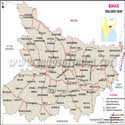
Bihar Map
The Bihar map provides a map of one of India's most historically significant states. Bihar, which is situated in the eastern part of India, has many ancient objects, cultural diversity, important cities, rivers, districts and historical landmarks. Bihar map is helpful in understanding the geographical location, District boundaries, Administrative divisions, major cities and the adjoining state of Bihar. The Bihar location overview helps users understand where the state lies on the India map and its geographical importance.Students, travellers, researchers and anybody interested in the geography, history and development of Bihar can find it useful to have this map of Bihar available to them, showing the different districts and cities. The state is divided into 38 districts and has a precious combination of ancient traditions, educational institutions, agriculture and growing industries.
Bihar
Bihar is situated in the eastern part of India and is the third largest state in terms of population and 12th in area of the country. The area of the state is around 94,163 km² (36,357 sq mi). The southern part of Bihar became the new state of Jharkhand on 15th November 2000.
The state has 38 districts and shares borders with Uttar Pradesh in the west, Nepal in the north, West Bengal in the east and Jharkhand in the south. Bihar is of great importance when it comes to Indian mapping, linking the northern and eastern parts of the nation. The Bihar location makes it an important region for understanding eastern India’s geography.
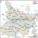
As a state in India, Bihar lies on the fertile banks of the river Ganga, has been home to some of the world's earliest civilizations, has some of the most religiously significant sites, and is also a place rich in cultural heritage.
History
Bihar has a rich history that dates back to ancient times. It was once a centre of learning, culture and political influence in India. Bihar was the birthplace of several powerful kingdoms and empires and also had its own share in Indian history.
During the Mahajanapada period in India (6th century BCE – 4th century BCE), the kingdom of Magadha was one of the 16 ancient states of India, located in the current state of Bihar. Subsequently, Magadha grew under strong rulers and was a base for the formation of great empires such as the Mauryan. The empire extended over much of India and beyond under Emperor Ashoka's rule.
Buddhism is also an important aspect of Bihar. The place where Gautama Buddha got enlightened under the Bodhi tree is Bodh Gaya, Bihar. The State is home to some of the world's oldest learning centres, where scholars from all over the world used to come to study at Nalanda University and Vikramshila University.
Bihar underwent changes under different rulers during the medieval period. After the Battle of Buxar, the area was under British rule and included in the Bengal Presidency. Bihar and Odisha were separated from the Bengal Presidency in 1912, and in 1936, Bihar and Odisha were made separate provinces. Bihar is an Indian state that emerged after the Indian Independence in 1947.
Economy
Bihar is one of the fastest-growing states in India. The farming sector still plays a significant role in the state economy, and the number of people engaged in farming activities is considerable. Bihar is one of the important states of India in producing Vegetables and also in Horticulture and Fruit production.
Because of its fertile land and favourable climate, the state has various crops and fruits. Bihar has also seen progress in the industrial sector, apart from agriculture. Barauni Oil Refinery and power projects in Muzaffarpur help to promote industrial development.
Fatuha is part of the Patna Metropolitan Region, which is famous for industries like Farm Tractor and Scooter Manufacturing. Bharat Petroleum LPG bottling plant is also functional in Fatuha. Bihar is also famous for sugar industries, which make a significant contribution to the economy of the state.
Places of Attraction
Historical, cultural and religious tourism are popular in Bihar. There are several ancient monuments, archaeological sites and religious sites in the State which represent its splendid legacy.
Important tourist places in Bihar are:
- Bodh Gaya and the Mahabodhi Temple: An important Buddhist pilgrimage sites.
- Bodhi Tree: the place where Gautama Buddha got enlightened.
- Nalanda ruins: ruins of the ancient centre of learning.
- Vikramshila Monastery at Bhagalpur
- Barabar Caves: a historic site and one of the oldest rock-cut caves in India.
- Tomb of Sher Shah Suri.
- The ruins in the ancient city of Vaishali
- Buddha Smriti Park in Patna
- Takht Sri Patna Sahib: a significant religious edifice of the Sikhs, and it is related to Guru Gobind Singh Ji.
Language
Hindi is the state language of Bihar, and Urdu is recognized as 2nd official language. There are a number of regional languages widely used throughout the state, such as Bhojpuri, Maithili, Magahi, Bajjika and Angika.
Maithili is listed in the Eighth Schedule of the Indian Constitution and is an official language of the Indian Union. These languages are a reflection of Bihar's cultural diversity.
Education
Bihar has a rich educational legacy with some of the world's oldest universities. The state now has some significant educational institutions that provide higher education and research.
The Biggest institutes in Bihar are:
- Indian Institute of Technology, Patna
- National Institute of Technology, Patna
- All India Institute of Medical Sciences, Patna
- Patna University
- Aryabhatta Knowledge University
- Bihar Agricultural University
- Dr B.R. Ambedkar Bihar University
- Mahatma Gandhi Central University
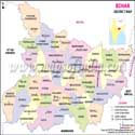
Bihar Map with Districts
Bihar district map is the administrative districts and boundary map of Bihar state. The Bihar map of district provides detailed information about district boundaries, locations and administrative divisions of the state. Bihar District Map with District List, Bihar Cities Map, Bihar Regions Map provides detail location of districts, headquarters and regions of Bihar.
The updated district map of Bihar shows the district boundaries, division-wise district distribution, names of all districts of Bihar, major cities and administrative centres of Bihar.
Bihar is divided into nine administrative divisions:
- Patna Division
- Saran Division
- Tirhut Division
- Darbhanga Division
- Kosi Division
- Purnia Division
- Bhagalpur Division
- Munger Division
- Magadh Division
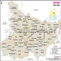
Bihar Map Showing Major Cities
Bihar City Map shows the major cities of Bihar state in the country and their importance in administration, education, trade and tourism. The Bihar cities section helps users identify important urban areas and understand the importance of different cities in Bihar.
Patna
Patna is the capital of Bihar and is one of the oldest cities inhabited continuously in the world. It is the administrative, educational and economic hub of the state.
Gaya
Gaya is a well-known religious city which is famous for Bodh Gaya and the Mahabodhi Temple. It becomes a Buddhist holy place and a tourist destination for pilgrims and tourists from all over the world.
Muzaffarpur
Muzaffarpur is one of the important trade centres of Bihar and is well known for its production of Shahi Litchi.
Bhagalpur
Bhagalpur is famous for its silk industry and is termed the “Silk City of India”. It is also an important educational and cultural centre.
Darbhanga
Darbhanga is also known for its rich cultural heritage and traditional music, and it is also an important historic city in the Mithila region.
Purnia
rnia is an important city in the north-east of Bihar and is a major trade and agricultural hub.
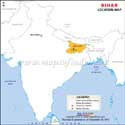
Bihar Location on India Map
Bihar is in the eastern part of India and holds a significant geographical location in the country. The Bihar location on the India map explains its position between northern and eastern India. The state is located in the fertile Gangetic plains and borders 4 areas.
Neighboring states and regions of Bihar:
- Uttar Pradesh to the west
- Jharkhand to the south
- West Bengal to the east
- Nepal to the north
Bihar District Information
A detailed Bihar district map with information helps users quickly understand the administrative structure, district locations, and important regional divisions of the state.
| District | Headquarters | Division |
|---|---|---|
| Patna | Patna | Patna |
| Gaya | Gaya | Magadh |
| Nalanda | Bihar Sharif | Patna |
| Muzaffarpur | Muzaffarpur | Tirhut |
| Bhagalpur | Bhagalpur | Bhagalpur |
| Darbhanga | Darbhanga | Darbhanga |
| Purnia | Purnia | Purnia |
| Saran | Chhapra | Saran |
| Munger | Munger | Munger |
| Vaishali | Hajipur | Tirhut |
Bihar State Information | |
|---|---|
| Capital | Patna |
| Date of formation | 26/01/50 |
| Governor | Lt Gen Syed Ata Hasnain (Retd.) |
| Chief Minister | Samrat Choudhary |
| Tourist attractions | Rajgir, Nalanda, Vaishali, Pawapuri, Bodh Gaya, Vikramshila, Gaya, the ancient city of Patliputra |
| Festivals | Chatth Puja, Sama-Chakeva, Nag Panchami |
| Major dance and music forms | Jat-Jatin dance of the Mithila region, Bidesia, the songs of Vidyapati, Chau Tribal dances |
| Arts and crafts | Madhubani painting; Madhubani's marsh `sikki. Grass is used to make baskets, toys, dolls etc; Sujini kantha embroidery is a specialisation of Bihar. |
| Languages | Hindi, Urdu, Santhali |
| Size | 94,163 sq. km |
| Population (Census 2011) | 104099452 |
| Rivers | Kosi, Ganga, Saryu, Gandak, Kamla, Panar, Saura, Pun-pun |
| Forests and wildlife sanctuaries | Valmiki NP, Rajgir WS, Bhimbandh WS, Gautam Buddha WS, Udayapur WS |
| State animal | Gaur (Mithun) |
| State bird | House sparrow |
| State flower | Kachnar (Phanera variegata) |
| State tree | Peepal |
| Major crops | Paddy, wheat, maize |
| Factoids | A peepal or Bodhi tree in Bodh Gaya marks the spot where Buddha achieved Enlightenment. |
| Nalanda University, a seat of Buddhist learning, was founded around the 5th century AD by King Kumaragupta I | |
| No. of District | 38 |
FAQs
Q1: How many districts are there in Bihar?
Bihar has 38 districts divided into 9 divisions.
Q2: Which is the largest district in Bihar?
West Champaran is the largest district in Bihar by area, covering around 5,228 sq km.
Q3: Which cities are shown on Bihar map?
Major cities include Patna, Gaya, Muzaffarpur, Bhagalpur, Darbhanga, and Purnia.
Q4: Where is Bihar located on India's map?
Bihar is located in eastern India, bordered by Uttar Pradesh, Nepal, West Bengal, and Jharkhand.
Q5: What is the capital of Bihar?
The capital of Bihar is Patna.
Q6: Which districts are shown in Bihar district map?
It shows all 38 districts, including Patna, Gaya, Nalanda, Muzaffarpur, Bhagalpur, and Darbhanga.
Q7: What are the neighboring states of Bihar?
Bihar borders Uttar Pradesh, Jharkhand, West Bengal, and Nepal.
Maps in Other Regional Languages
Last Updated on: July 13, 2026