

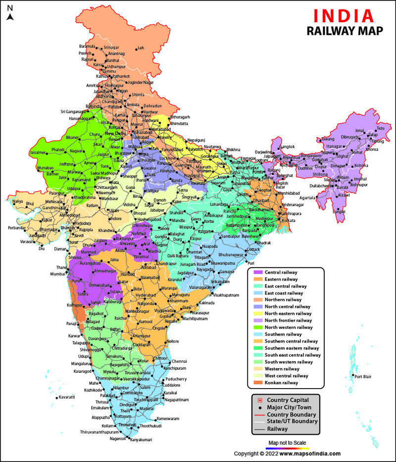





Railways Network in IndiaIndia Railway Network Map is the principal mode of transportation for freight and passengers in India, and plays an important role in the development of industries and agriculture. Indian Railways has had the distinction of being one of the biggest and busiest rail networks in the world. It operates thousands of passenger trains and transports millions of passengers every day. The Indian Railway employs a large workforce across its various zones and divisions. The Indian Railways has been serving the people of India with utmost pride for more than 170 years. The first train journey was made in India in the year 1851, between Roorkee and Piran Kaliyar - for transferring large quantity of clay to Rorkee. The first passenger train journey became operational on 16 April 1853 between Bori Bunder, Bombay and Thane, covering a distance of about 34 km, thus marking the formal birth of the rail network in India. The Indian Railway network binds the social, cultural and economical fabric of the country and covers the whole country ranging from North to South and East to West narrowing the distance barrier for its people. The railway network of India has brought together the whole of country, hence creating a feeling of unity among Indians. India’s bid to take trains to Himalayan heights and the Railway’s aim to provide connectivity to all state capitals of the north-eastern region, led The Northeast Frontier Railway (NFR) to operate a train between Dibrugarh and Naharlagun. Arunachal Pradesh finally has the much-needed railway connectivity. As per media reports, Naharlagun, a town near the state capital Itanagar, is now part of the railway map of India. The Harmuti-Naharlagun line, which became functional in April 2014, was conceived in 1997 as part of a greater plan to improve connectivity in the Northeast. Railway Connectivity in Arunachal PradeshIndia’s bid to take trains to Himalayan heights and the Railway’s aim to provide connectivity to all state capitals of the north-eastern region led the Northeast Frontier Railway (NFR) to operate trains between Dibrugarh and Naharlagun. Arunachal Pradesh finally received the much-needed railway connectivity. Naharlagun, a town near the state capital Itanagar, is now part of the railway map of India. The Harmuti–Naharlagun line, which became functional in April 2014, has played an important role in improving railway connectivity in Arunachal Pradesh and the Northeast. |
Check - Indian Railways Time Table
Indian Railways Railway Zones
Indian Railways currently operates through 17 railway zones, while South Coast Railway has been established as a new zone. Kolkata Metro is also administered as a separate railway zone.
| Indian Railways is divided into 18 zones: | |
|
|
FAQs
Q1: How large is the railway network in India?
Indian Railways is one of the world’s largest railway networks, connecting major cities, towns, industrial centres and remote regions across India.
Q2: When did the first passenger train run in India?
India’s first passenger train ran on 16 April 1853 from Bori Bunder in Bombay (Mumbai) to Thane, covering about 34 km.
Q3: How many railway zones are there in India?
Indian Railways currently operates through 17 railway zones, while South Coast Railway has been established as a new zone. Kolkata Metro is administered separately as a zonal railway.
Q4: Which railway zone covers Northeast India?
The Northeast Frontier Railway (NFR) serves most of Northeast India and plays an important role in expanding railway connectivity across the region.
Q5: When did Arunachal Pradesh get railway connectivity?
Arunachal Pradesh received broad-gauge railway connectivity in April 2014 with the completion of the Harmuti–Naharlagun railway line.
Q6: What is the importance of the Indian Railway network?
The Indian Railway network supports passenger transportation, freight movement, trade, agriculture and industrial development, while connecting different parts of the country.
Q7: Which is the oldest passenger railway route in India?
The Mumbai–Thane route is recognized as India’s first passenger railway route, with the inaugural journey taking place on 16 April 1853.
Last Updated on: July 28, 2026
Related Links