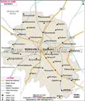
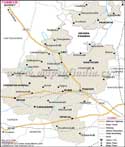
Chamarajanagar District in southern
Karnataka came into its official existence after the larger Mysore district was bifurcated into the new Mysore district and the current Chamrajnagar District (662 m above sea level).
The district stretches between 11°92'North to 76°95' East and is encircled by Erode District of Tamil Nadu and Wayanad District of Kerala.
As per the 2001 Census Report, Chamrajnagar has a population of 60,810. Agriculture forms the economic backbone in the district richly endowed in its mineral deposits.
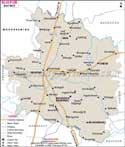
Chamarajanagar, on the banks of the Cuvery River is a treasure trove of religious and cultural legacy. The legendary Malemahadeshwara Betta shrine accompanied by its annual car rally attracts flocks of tourists. Abounding in natural beauty, the revered temples of BR Hills, the wildlife reserves like the Bandipur Wildlife Sanctuary and
Biligirirangana Hills Wildlife Sanctuary, Kaveri Fishing Camp and stately Mahadeswara hills are definitely worth visiting.