Davangere District Map


District Map of Davangere

separator Click here for Customized Maps arrow custom map
District Map of Davangere Gadag Bellari Chitradurga Chikkamagaluru Shivamogga Haveri
Print Email Save Buy Now 
*District Map of Davangere highlights national highway, major roads, railways, rivers, etc. Disclaimer


  Major Districts of Karnataka  
Bangalore District Map Belgaum District Map Gulbarga District Map Shimoga District Map
Bangalore District MapBelgaum District MapGulbarga District MapShimoga District Map
    
Tumkur District Map Bijapur District Map Dakshin Kannad District Map Mysore District Map
Tumkur District MapBijapur District MapDakshin Kannad District MapMysore District Map
  other districts of Karnataka  >>

Davanagare District, located in the heart of Karnataka owes its nomenclature to the term " Davana Kere" meaning "Village of Lake". The district is shrouded in antiquarian history, which dates back to the Chalukya and Pandya Dynasty.
Occupying an area of 5924 sq. km and stretching between the geometric coordinates of 14°28' N and 75°55' E, Davanagere was split from Chitradurga District in 1997.

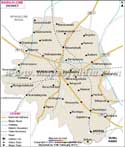
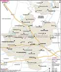
As per the 2001 Census, Davanagare District has recorded population of 1,790,952. The district was accorded the nom de plume 'Manchester of India' due to its finest quality cotton produced in its premium cotton mills and handlooms. Agriculture too forms the district's economic backbone.

Davanagere District abounds in natural splendor with its panoramic landscape and ornate architectural landmarks. The

  • Durgambika Temple
  • Chennagiri Rangappa Clock Tower
  • Comprehensive Water Supply Scheme (T V Station)
  • St. Thomas Church deserves special mention.


Last Updated on : May 17, 2018


-->