
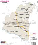
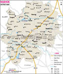
Geographic Location of Ahmednagar:
Ahmednagar is situated on the west bank of the Sina River. It is located at about 120 km northeast of Pune and 120 km from Aurangabad.
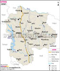
Climatic Condition of Ahmednagar:
Being away from the sea the climate is hot and dry. Major chunk of the year faces hot summer and dryness during the monsoon season. The hilly western zone of the district enjoys a comparatively cooler climate. During the winters the air is dry and refreshing. As compared to the eastern part of the district the western hilly region receives more rainfall. However in general rains are often scanty. This often results in drought.
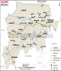
History of Ahmednagar:
Ahmednagar is one of the foremost industrial districts having industries like automobile, electronics, heavy industries, agriculture equipment, sugar co-operative etc. it has numerous small and large scale industries. Industries where grains are separated from husks, gathering of medicinal plants, bidi rolling, jaggery making make up small scale industries. Whereas, large scale industries are those engaged in the production of `Ayurvedic` medicines, manufacturing mopeds, engines, pump and T.V. sets, pharmaceutical and sugar factories.
Ahmednagar houses a number of co-operatives such as sugar, milk and bank co-operatives. It is home to 19 sugar factories and is also the birthplace of the cooperative movement. Ahmednagar has the maximum number of sugar factories in India. The foremost cooperative sugar factory in Asia was established at Pravara Nagar.
Renowned Educational institutes in Ahmednagar:
- Abasaheb Kakade College of Pharmacy
- Amrutvahini College of Engineering
- B.P.H.E. Society's Institute of Management Studies Career Dev & Research
- College of Engineering Ahmednagar
- College of Engineering Kopargaon
- Khasdur Shri Govindrao Adik Law College
- Masumiya Shikshan Shastra Mahavidyalaya
- Nav Maharashtra Shikshan Mandal College of Education
- New Law College Ahmednagar
- Pravara Rural Engineering College
- Rayat Institute of Management Research for Rural Development
- Shri Omkarnath Malpani Law College
- SMBT Dental College & Hospital
- SRES College of Engineering
- Yash Palace Hotel
- Panchsheel Hotel
- Natraj Hotel
- Chanakya Hotel
- Ashoka Tourist Hotel
- Sanket Hotel
- Tulsi Vihar Hotel
- Oberoi Hotel
- Swastik Hotel
- Raj Residency Hotel
Ahmednagar has the biggest cricket stadium in Maharashtra provided with international standard sporting facilities. Meher Baba first came to the then city of Ahmednagar in 1923. He stayed at Khushru Quarters. This has later been made the current location of the Avatar Meher Baba Perpetual Public Charitable Trust. He stayed here for a very long time and while staying in this city for such a long period he has made Ahmednagar a location for his work.
So you must not miss the city of Ahmednagar because this has long been the place of notable landmarks of nation's history. Plans have been made by the government to a plan develop the city by 2031.
Last Updated on : May 12, 2026