
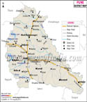
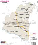
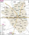
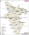
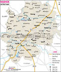
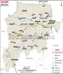
Chandrapur is one of the largest districts in the state and is a renowned tourist spot as well as major trading hub. It was formerly known as, 'Chanda' district and was later renamed as Chandrapur in 1964.
The district is located in the eastern part of the state. The city of Nagpur is within easy reach from the district. Chandrapur is surrounded by Bhandara, Wardha and Nagpur.
Climate of Chandrapur
The climate of Chandrapur is mostly tropical. Summer months are mostly hot and humid while the winter season is moderate and pleasant. The ideal time for traveling to Chandrapur is between the months of October and March.
imur
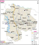
- Rajura
- Chandrapur
- Ballarpur
- Warora
- Brahmapuri
- Chimur
Chandrapur district is a popular travel destination. Plenty of sightseeing trips are offered by the tourist board and travel agencies. Some of the popular tourist attractions in Chandrapur are:
- Tadoba National Park
- Ankleshwar Temple
- Mahakali Temple
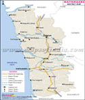
The nearest airport is situated in the city of Nagpur. Nagpur can be easily accessed from various parts of the district. Train services link Chandrapur with various parts of Maharashtra like Pune, Kolhapur, Mumbai and so on. Road network is also well developed.
Hotels in Chandrapur
- Kundan Plaza Hotel
- Anuja Hotel
- Deepak Hotel
- Ganpati Hotel
- Girnar Deluxe Hotel
- Siddarth Hotel
- Mayur Hotel
Last Updated on : May 12, 2026