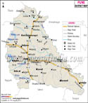
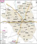
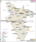
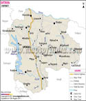
Hingoli is an administrative district in Maharashtra. Hingoli city is its headquarters. Situated on the northern part of Marathwada, Hingoli district is bordered by Akola, Yeotmal , Parbhani and Nanded.
4,526 kilometers the district has a population of around 987,160. Hingoli district was formed in the year 1999. Hingoli and Basmath are the 2 sub-divisions of the district. The Hingoli District Map gives information about the district boundaries, district headquarter, river, taluk headquarter and railway.
Tourist Attractions in Hingoli District:
Hingoli District is dotted with several tourist attractions. The travelers love to explore the tourist places located in and around the district. Some of the tourist spots are:
Tulaja Devi Sansthan: The Tulaja Devi Sansthan is one of the oldest temples of Hingoli District. The temple was dedicated to Hindu goddess Tulja Bhavani.
Aundha Nagnath: Aundha Nagnath is an important religious spot of the district. Dedicated to Lord Shiva, Aundha Nagnath is regularly visited by pilgrims especially during shivratri and Vijayadashmi from various corners of India. It is said that Dharmraj bulit this temple. The exquisite carvings of the temple made it worth visiting.