
In 2001 Nagpur was declared as India's 13th largest urban conglomeration. Globally, Nagpur stands as the 114th largest city. Nagpur lies precisely at the centre of India.
The main attraction and centerpiece of the city is the British fort built in 1818 on the twin hills of Sitabuldi.
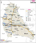
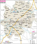
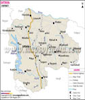
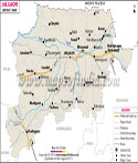
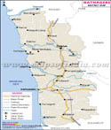
Geographic Location of Nagpur:
The district stretches to almost 9897 sq km. The zero milestones of India lie in Nagpur. Situated 274.5 meters to 652.70 meters above sea level 28% of the town is covered by Forest. Nagpur is surrounded by plateau rising northward to the Satpura Range. Kanhan and Pench rivers are the two important rivers of the district. River Wardha in the west and Wainganga in the east merge as tributaries of Godavari River.
nsus report states that the population of Nagpur is 2.5 million.
Time zone:
Nagpur follows Asia/Kolkata time zone id.
Industries in Nagpur:
First textile mill of India was built in the Nagpur city. Nagpur houses several renowned national level scientific and governmental establishments like:
- National Environmental Engineering Research Institute NEERI
- Central Institute of Cotton Research (CICR)
- National Research Centre for Citrus
- National Bureau of Soil Survey and Land Use Planning
- Jawaharlal Nehru National Aluminum Research and Development Centre
- Petroleum and Explosives Safety Organization (PESO)
Languages spoken in Nagpur:
The language of Nagpur is basically bilingual. The two languages at Nagpur that are widely spoken throughout the city are Hindi and Marathi. Marathi is the state language in Nagpur whereas Hindi being the national language is also very popularly spoken in the city of Nagpur.
Educational institutes in Nagpur;
Nagpur Engineering Colleges
- Raisoni Engineering College
- Priyadarshini Engineering and Architecture
- VNIT
- LIT
- C V Raman Engineering College
- Govt. Medical College
- Indira Gandhi Medical College
- Government Medical College and Hospital
- Indira Gandhi Medical College and Hospital
- Madhuribai Deshmukh Institute of Nursing Education
- Mandal School of Nursing
- Mure Memorial Hospital School of Nursing
- VSPM College of Nursing and Research Centre
- Dr. Ambedkar College
- Raja Dharmrao Law College
- SP College of Law
- Dr.Panjabrao Deshmukh Krishi Vidyapeeth
- Institute of Management Technology (IMT)
- Yuva School of Management (YSM)
- Central India Institute of Management Studies
- Shri Ramdeobaba Kamla Nehru Engg College (SRKNEC)
- Department of Business Management, Nagpur University
- Dr. Ambedkar Institute of management Studies and Research
- Lokmokmanya Tilak Institute of Management Studies
List of popular and luxury hotels in Nagpur:
- The Pride Hotel
- Tuli International
- Hotel Centre Point
- Hotel Hardeo
- Hotel Jagsons
- Hotel Chanakya Modi
- Hotel Dua Continental
- Hotel Blue Moon
- Hotel Rawell Continental
- Weizmann Hotels Ltd
Some of the prominent attractions of the Nagpur district are as follows:
- Dragon Palace temple
- Jadu Mahal, Ambazari Lake
- Pench National Park
- Balaji Mandir
- Sitabuldi Fort
- Maharaj Baug
Last Updated on : May 12, 2026