
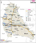
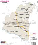
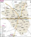
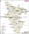
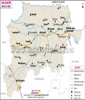
Later in 1864 the taluka of Yavatmal were included first into South East Berar district and later Wani district. In 1905 the Yavatmal district was formed. Yavatmal District Map is of great use on tour to the district.
Geographic Location of Yavatmal:
The district is situated in the Wardha Penganga-Wainganga plain. To the north of the district are the Wardha and Amravati districts. To the east is Chandrapur district and to the south are Nanded district and the state of Andhra Pradesh. The districts of Parbhani and Akola also surround Yavatmal.
Climatic Condition of Yavatmal:
Yavatmal generally experiences hot and dry summers while moderately cold winters. Temperature is extremely high during the summers. During the summers daily temperature is about 42 degree Celsius. While in the winters, daily temperature is about 13 degree Celsius. Monsoons are humid in the Yavatmal district.
Languages spoken in Yavatmal:
Marathi, English, Hindi and Urdu are the common dialects used by the people of Yavatmal.
Demographics of Yavatmal:
The population of the district is around 2077144.
Economy of Yavatmal:
Yavatmal district is one of the major cotton growing districts in the state. Cotton is an important cash crop here.
Industries in Yavatmal:
There are several small-scale and large scale industries in Yavatmal district a few of them are discussed below.
Short scale industries:
- Handloom
- Rolling Bidis
- Handmade Paper
- Ginning and Pressing Mills
- Spinning Mills
- Sugar Factory
- Oil Mills
- Babasaheb Naik College of Engineering
- Gunwantrao Deshmukh College of Education
- Jawaharlal Darda Institute of Engineering & Technology
- Shri Vasantrao Naik Government Medical College
- Manoharrao Nanasaheb Deshmukh Arts & Science College
- Janata Shikshan Prasarak Mandal's Phulsing Naik Mahavidyalaya
There are a number of tourist destinations in the district. Fairs are also held in various parts of the district throughout the year. Some of the places worth a visit are Kalamb, Arni, Wani, Ghatanji and Kaleshwar.
Some of the important fairs held here are Shri Ranganath Swami and Ghanti Baba at Digras and Wani. The town of Ghatanji hosts Maroti Mahraj fair, Wani hosts Mahashivaratri, Kalamb hosts Shir Chintamani fair and Mahur hosts Datta jayanti fair.
Hotels in Yavatmal:
Midtown Hotel,
07232 - 242438
Hotel Revati Pride,
07232 - 255040
Hotel Gulmohar
07232 - 246752
Gyansons Hotel
07232 - 243288
Hotel Galaxy
07232 - 244369
Hotel Dwarka Delux,
07232 - 244232
Hotel Asharay
07232 - 242310
Hotel Paradies
07232 - 241289
Getting to Yavatmal:
The district headquarters Yavatmal town is connected to various tehsil headquarters. The town is also connected by a railway line with Achalpur.
Last Updated on : May 12, 2026