


About three-fourths of the population earns their livelihood from agriculture. Paddy, maize, mustard, sugarcane, sesame, fiberless ginger, and potatoes are the main crops grown in this area.
Its economy depends on forest products, silkworms, tourism, and horticulture. The climatic conditions in Mizoram are ideal for the breeding of all types of silkworms. Sericulture is one of the major industries in Mizoram. The state produced raw silk around 88 metric tonnes during April-December 2019.
Mizoram is known for a generation of hydropower. It has the potential to generate 4,500 megawatts (MW) of hydropower. Small-scale irrigation projects have been developing to increase crop yield. But there is a dearth of big industries in the state.
Small-scale industries include sericulture, handloom and handicrafts industries, sawmills and furniture workshops, oil refining, grain milling, and ginger processing are running. The service sector comprises Tourism, Real Estate, and Insurance.
Mizoram State Information | |
|---|---|
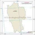
| Capital | Aizawl |
| Date of formation | 20. Feb. 1987 |
| Governor | General (Dr.) Vijay Kumar Singh |
| Chief Minister | Lalduhoma |
| Tourist attractions | Phawngpui, Sibuta Lung, Philpui Grave, Pangzawl |
| Festivals | Chapchar Kut, Mim Kut, Pawl Kut |
| Major dance and music forms | Khal Lam, Chai, Chhilam, Sawlkin |
| Arts and crafts | Puan; cane and bamboo baskets, pipes, toys that utilise the natural elasticity of bamboo |
| Languages | Lushai, Mizo, Bengali, Lakher |
| Size | 21,081 sq. km |
| Population (Census 2011) | 1091014 |
| Rivers | Tlwang, Teirei, Chhimtuipui, Tuichawng, and so on. |
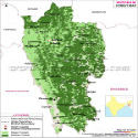
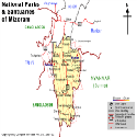
| Forests and wildlife sanctuaries | Lengteng WS, Murlen NP, Phawngpui NP, Thorangtlang WS |
| State animal | Himalayan Serow |
| State bird | Hume's bartailed pheasant |
| State flower | Red Vanda |
| State tree | Indian rose chestnutt |
| Major crops | Paddy, wheat, bamboo, oil palm |
| Factoids | Cheraw or the bamboo dance is a popular form of dancing. |
| Pukzing cave, near Aizawl stands at 25 m. Legends say that Mualzavata, a very strong man, carved it out with a hair pin. | |
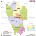
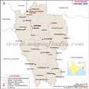
| No. of District | 11 |
Last Updated on : April 17, 2026