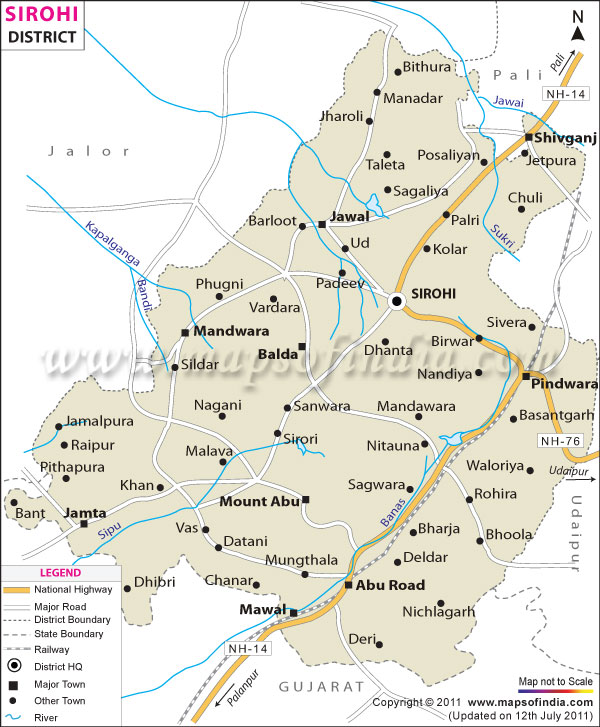
The district of Sirohi lies in the south-western part of Rajasthan state. It is spread over an area of 5136 sq km, which is almost 1.52% of the area of Rajasthan. Its neighbors are in the east, Banaskantha District (Gujarat) in the south, Pali in the north-east and Jelore in the west. Shaped in the form of a triangle, the Harji village is located at the apex or extreme north portion of the district. Mount Abu is located in the southern part of Sirohi District.
Divisions of Sirohi District:
The district has 5 tehsils divided amongst 3 sub-divisions. The 5 tehsisls are Pindwara, Abuorad, Reodar, Sirohi and Sheoganj. Sirohi Town is the headquarters of the district. The total population of the district is 8,50,756 as per 2001 census. The district has 1 Zilla Parishad, 5 Panchayat Samitis and 151 Gram Panchayats.
History of Sirohi District:
The name of the district has been derived from Siranwa Hills. The founder of present day Sirohi was Sehastramal who was the son of Rao Sobha ji. He founded the city in the year 1425 AD. Sirohi, an important Rajput province, was always an independent state since ancient times. After India gained her independence, an agreement was signed between the ruler of Sirohi State and the central government by virtue of which it came under the jurisdiction of the Bombay Government from 5th January, 1949 till 25th January, 1950. It finally became a part of Rajasthan in the year 1950.
Economy of Sirohi District:
Agriculture is the main economic activity carried out in this region. The major crops that are grown over here include wheat, barley, castor seed, sorghum, pulses, sesame, mustard, bahra and maize. Besides this, one can also find a large number of chemical, plastic as well as cotton spinning industries over here.
Tourist Attractions in Sirohi District:
The most famous tourist attraction of Sirohi District in Rajasthan is the Mount Abu. It is the only hill station of Rajasthan and is visited by hoards of tourist every year. Travelers can enjoy boating facilities and also go for shopping over here.
Apart from this, the other main attractions of the district that also feature in the list of prime tourist attractions in Rajasthan include:
- Sarneshwar Ji Temple°
- Sarvadham Temple°
- Pava Puri Temple°
- Sun Temple at Varman°
- Chandravati°
- Ambheshwar Ji Temple°
- Mirpur°
- Vasantagrh°
- Ajari°
- Bheru Tarak Dham°
- Jiraval- A Jain pilgrimage center.
Getting to Sirohi District:
In order to get to Sirohi, travelers can drive down National Highway 14, which links it to Gujarat and Pali. The State Highway number 19 links the district with Jelore District. There are a good number of tourist buses that ply to and fro from these places.
There are several trains connecting the district with the rest of Rajasthan and India as a whole. The railways stations at Sirohi Town and Abu are the primary railway stations. Other nearby stations are Bans, Saoopganj, Kishanganj, Kviralli, Maval and Morthala. Trains operating along the Ahmedabad-Delhi line pass through Sirohi District.
The airport at Udaipur is the nearest o the district, almost 110 km. This airport is served by a good number of flights from Jaipur and other cities. Aburoad and Sirohi also have an airstrip.
| Facts of Sirohi District | |
|---|---|
| State | Rajasthan |
| District | Sirohi |
| District HQ | Sirohi |
| Population (2011) | 1,036,346 |
| Growth | 21.76% |
| Sex Ratio | 940 |
| Literacy | 55.25 |
| Area (km2) | 5136 |
| Density (/km2) | 202 |
| Tehsils | Abu Road, Pindwara, Reodar, Sheoganj, Sirohi |
| Lok Sabha Constituencies | Jalore |
| Assembly Constituencies | Pindwara-Abu, Reodar, Sirohi |
| Languages | Hindi, Rajasthani including Marwari |
| Rivers | Jawai, Sukhadi, Khari, bodi, krishnavati, kapalganga, and Banas |
| Lat-Long | 24.75182,72.816582 |
| Travel Destinations | The Ancient Mirpur Jain Temple, Ambeshwar Mahadev Temple, Jabeshwar Mahadev Temple, Moriya Baba Temple, Kusuma, Baneshawari Mataji Temple, Lakhav Mata Temple, Markundeshwar temple, Mount Abu, Pavapuri Jain temple, Chandravati Temple, Saraneshwar Mahadev Temple etc. |
| Government Colleges/Universities | Government College (Sirohi), Government Girls College (Sirohi), Government Law College (Sirohi), S.M.C.C. Government College (Abu Road), S.M.P.B.J. Government College (Sheoganj) etc. |
Last Updated on : November 13, 2025
