Uttarakhand Map |
उत्तराखंड का नक्शा |
|
|||||

| |||||
|


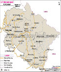
| *Map showing major roads, railways, rivers, national highways, etc. |
 |
 |
 |
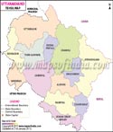 |
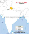
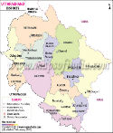
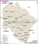
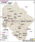
| Uttarakhand Location Map | Uttarakhand District Map | Cities of Uttarakhand | Uttarakhand Tehsil Map |
 |
 |
 |
 |
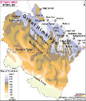
| Uttarakhand Road Map | Uttarakhand Physical Map | Uttarakhand Railway Map | Uttarakhand Travel Map |
Uttarakhand is a mountainous region of dramatic topography in the northern part of India that possesses sacred rivers, and rich cultural history. Uttarakhand is a land between the plains of the northern part of India and a high range of Himalayas and it is a significant geographical and spiritual zone that, during centuries, had been paid attention to by pilgrims, travelers, and scholars. It borders China and Nepal internationally and Uttar Pradesh, Himachal Pradesh and Haryana internally.
The capital of Uttrakhand is Dehradun which is a major administration and learning center. The other major city is Haridwar that is often regarded as one of the sacred sites of pilgrimage in Hinduism. The state also boasts many temples and pilgrimage paths which are visited by millions of the population every year.
The state of Uttarakhand is also outlined in terms of natural beauty. Mountains are snow-covered, the valley is wide, the plateau fields are huge, and running watercourses form a beautiful landscape under which the tourism and pastoral life is based. Himalayan range is the spine of geography of the region and it affects climatic factors in addition to the biodiversity and distribution of settlements.
Agricultural activities and tourism are great and important in the economy. Many communities depend on farming activities such as terrace farming as their primary source of livelihood. The pilgrimage, trekking and wildlife explorations bring about the economic development of the tourism sector. The natural environment of Uttarakhand is also provided with forests, national parks and wildlife reserves with different plants and animals.
The state is usually referred to as the Devbhumi, the home of gods because of having many temples and sacred places. The religious traditions, the cultural feasts, and local traditions make the everyday life of the people of Uttarakhand to create this particular bundle of spirituality and mountain culture certainty.
History
The history of Uttarakhand stretches back to ancient times and is closely related to the myths and religious practices as well as the initial inhabitants of the Himalayan valley. The mountains and rivers in this region are often mentioned in ancient Hindu scriptures, and are presented as places of spiritual practice and pilgrimage, being considered sacred landscapes.
The region was occupied by different communities who resided in small settlements where they engaged in agricultural and pastoral activities in the early historical periods. A number of local dynasties emerged with time and settled in various regions of the mountainous region forming kingdoms. These monarchs constructed temples, forts and settlements which acted as political and religious capitals.
In the medieval period, the region was ruled by different dynasties who controlled various regions of Uttarakhand such as the Katyuri and Chand. The dynasties promoted the establishment of temples and assisted the religious organizations, and this helped in making the area a significant pilgrimage hub. Numerous temples constructed during this period remain well known today and continue to be visited and worshiped.
The Himalayan roads that passed through the region also encouraged trade between India and Tibet. These routes were used by merchants, pilgrims, and travelers in order to transport products like wool, salt, and spices. These trade relations helped connect the Uttarakhand mountain communities to the rest of the Himalayan economies.
The British started expanding their control to the Himalayan area during the nineteenth century. The British separated much of the land and brought it under colonial rule after fighting with the Gurkha kingdom of Nepal. During this time roadways, mountain resorts and government offices were created.
In towns like Nainital, under colonialism, urban culture developed as a hill station where the British officials would come to avoid the heat of the plains. These towns later on served as significant tourist attractions because of their nice weather and natural beauty.
After India gained its independence in 1947, the region was incorporated into Uttar Pradesh. But the need for an independent hill state increased in the following decades because of geographical and cultural variations with the plains. It is only after some time that the new state of Uttarakhand came into being in 2000 and made a historic move in the modern political history of the region.
Culture
One of the most vital aspects of the culture in Uttarakhand is religious heritage. The state also boasts of several pilgrimage locations though the most popular temples are known as Char Dham temples which include Badrinath, Kedarnath, Gangotri and Yamunotri. The numbers of pilgrims visiting these temples are estimated at thousands every year and sometimes they have to take hard mountain trails in the quest to receive spiritual blessings.
The old festivals are based on the circle of the agricultural processes and religious faith of the folk. In both the villages as well as towns, festivals such as Makar Sankranti, Diwali and Holi are celebrated. The community gatherings, music and folk dances accompaniments come along with these festivals.
Dance and folk music constitute a major aspect of culture. Traditional dances such as Chholiya and Langvir Nritya are used during the social events and festivals. Such performances are normally followed by colorful costumes, and the application of traditional instruments.
Their culture is also creative and this is depicted through the handicrafts. The local crafts are shown in the form of woolen shawls, wooden carvings and ornaments that are made by fine artisans. These craftsmen market these handicrafts in the markets and tourist centres and incomes are generated to the rural communities.
The topography of the mountain has an impact on Uttarakhand cuisine and so are the local products. The food is plain yet healthy and it is made up of grains, lentils and veggies. The food available there is focused on the local food supply and it holds the rural lifestyle within the communities in the hills.
Language
The languages of Uttarakhand are rich and incorporate the diverse cultural background of the region. Hindi is the administrative, educational and media language. It is a common language widely spoken in towns and cities and is used as a connecting language among various communities.
Garhwali and Kumaoni are the primary languages in Garhwal and Kumaon regions respectively. The two languages have rich traditions of folk songs, poetry and other oral literature that has preserved the cultural heritage of the communities in the mountains.
In some circumstances Urdu and English are also used. English plays a significant part in higher education, tourism and government administration. Since the region receives international visitors and pilgrims, multilingualism is widespread.
The residents of Uttarakhand are usually raised in a multilingual environment. An average person can speak the local dialect at home, communicate in Hindi at the street and use English at the place of study or work. This is a multilingual context that is reflected by traditional culture and the contemporary social transformation.
Geography
The mountain system that supplies Himalayan mountain determines the climate of the area, vegetation and settlement patterns. The state is geographically dominated by three geographical regions that are high Himalayas, middle Himalayan ranges and foothill plains known as the Terai.
Some of the largest rivers that form in this area are the Ganges and the Yamuna. These rivers have enormous religious and ecological significance and sustains millions of inhabitants downstream.
The middle Himalayan region is composed of farming fields, valleys and forests. A lot of villages are found in these areas where people produce rice, wheat and millet by using traditional ways of farming. It is also the scenic beauty of these valleys that has stimulated tourism.
Preservation of the natural environment depends heavily on the protected areas. Among the most recognisable reserves is the oldest national park in India, Jim Corbett National Park which is known for its population of Bengal tigers and the variety of wildlife.
The southern part of the state is made up of the foothills that are called the Terai. It is a land with great agricultural potential which is warmer than the higher mountainous areas. Some agricultural settlements and towns are found here.
Uttarakhand happens to be one of the geographically diverse areas of India owing to the existence of tall mountains, significant rivers, forests and valleys. Its geographical features promote agriculture, tourism, wildlife conservation and spiritual practices that over centuries have created the character of the region.
A very large number of plant and animal species can also be found in the mountain ecosystems of the area. They are uniquely adapted to the high altitude environment. The vegetation on the higher altitudes is alpine, which is replaced by the dense forests in the middle level. These woods consist of oak, pine, deodar and rhododendron trees, which are of great value in the ecological aspect, as it prevents soil erosion and also conserves water resources. In spring, lots of rhododendron flowers occupy many hillsides recalling the color red-pink which forms an impressive natural landscape.
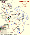
Demographics of Uttarakhand
| Country | India |
|---|---|
| State | Uttrakhand |
| District | 13 districts |
| Area | 20,682 sq mi |
| Population (Census 2011) | 10,116,752 |
| Coordinates | 30°20'N 78°04'E? / ?30.33°N 78.06°E |
Uttrakhand has 13 districts which are grouped into two divisions namely Garhwal division and Kumaon division.
The Garhwal division includes seven districts.
- Dehradun
- Uttarkashi
- Tehri Garhwal
- Rudraprayag
- Haridwar
- Pauri Garhwal
- Chamoli
- Almora
- Pithoragarh
- Nainital
- Bageshwar
- Champawat
- Udham Singh Nagar
Uttrakhand State Information | |
|---|---|
| Capital | Dehradun(Winter), Bhararisain (Summer) |
| Date of formation | 9. Nov. 2000 |
| Governor | Gurmit Singh |
| Chief Minister | Pushkar Singh Dhami |
| Tourist attractions | Corbett NP, Nainital, Almora Valley of Flowers, Nanda Devi Park |
| Festivals | Devidhura Mela, Nanda Devi Mela, Purnagiri Mela Major dance and music forms Garhwali folk dance and music |
| Arts and crafts | Kholi woodcarving; Aipan or rangoli |
| Languages | Hindi, Garhwali, Kumaoni |
| Size | 53,483 sq. km |
| Population | 10,086,292 |
| Rivers | Ganga, Yamuna, Ramganga, Kali |
| Forests and wildlife sanctuaries | Nanda Devi NP, Rajaji NP, Corbett Tiger Reserve. |
| State animal | Himalayan musk deer |
| State bird | Himalayan monal |
| State flower | Brahm kamal |
| State tree | Burans |
| Major crops | Rice, wheat, arley, jowar, oilseed |
| Factoids | Kedarnath temple, at a height of 3584 m, is devoted to Shiva. |
| The Kol-Munds, a Dravidian people, were probably the first to live here. | |
| No. of District | 13 |
FAQs
Q1: What information is available on the Uttarakhand map?
The Uttarakhand map provides information about state boundaries, districts, cities, highways, railway routes, rivers, mountain ranges, and important geographical features.
Q2: What is the capital city of Uttarakhand shown on the map?
Dehradun is the capital city of Uttarakhand and is marked as an important location on the state map.
Q3: Which states share borders with Uttarakhand?
Uttarakhand shares borders with Himachal Pradesh and Uttar Pradesh. It also shares an international border with Nepal and China.
Q4: Which are the major cities shown on the Uttarakhand map?
Major cities shown on the Uttarakhand map include Dehradun, Haridwar, Rishikesh, Nainital, Haldwani, Almora, and Mussoorie.
Q5: What is the importance of the Uttarakhand physical map?
The Uttarakhand physical map shows natural features such as mountains, rivers, valleys, and terrain patterns.
Q6: What is the importance of the Uttarakhand political map?
The Uttarakhand political map helps users understand state boundaries, districts, cities, and administrative divisions.
Q7: Which is the largest district of Uttarakhand by area?
Uttarkashi is one of the largest districts of Uttarakhand by geographical area and can be located on the district map.
Last Updated on : July 07, 2026