
Introduction
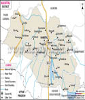
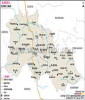
Almora is a major administrative unit in Kumaon branch of the Indian state of Uttarakhand. Such a picturesque Himalayan scenery, the historic towns and rich cultural heritage as well have been traditionally considered the cultural centres of the Kumaon region. It is located on a ridge on the Kumaon Himalayas. Researchers can often analyse the terrain using the Almora district map.
It is a well-known fact that there is a rich history of the district, traditions and strong relation to the Himalayan environment. Through the history of centuries, Almora district has acquired a unique identity which is marked by the ancient kingdoms, the influences of colonialism and ordinary lifestyle of the hill people. The Almora district map serving as a study area by many travellers and researchers to comprehend the mountainous region, settlement and cultural landscape.
History
The Almora district history is tightly related to the history of the whole Kumaon region of central go-around the Himalaya. The evidence found by archeologists indicates that human settlements in this place date back to the ancient times since the Himalayan valleys were the right place to live, carry out trade and agricultural activities which connected India with Tibet.
During the early historical times, the region was controlled by other local tribes and small kingdoms. The Katyuri dynasty which ruled the central Himalayas between the seventh and eleventh centuries were amongst the earliest known rulers of the Kumaon region. The surrounding areas had a number of temples and settlements that were built during their reign. The distribution of these settlements can be observed through the Almora district map.
The political significance of the Almora grew tremendously in the sixteenth century when Chand dynasty moved to settle their capital in the town of Almora. In 1560 the Chand rulers changed the capital of their state to Almora. The period under their reign was marked by administrative growth and building of temples, expansion of trade routes. According to many historians who have studied the Almora district map, the location of the town on a ridge made it easier to resist any form of invasion and dominate over the valleys surrounding the town.
Under the Chand rule, Almora flourished as a centre of culture, art and religion. A number of significant temples were constructed during this period including the Nanda Devi Temple among other shrines. The seeders also promoted trade with the neighbouring Himalayas regions and this led to the prosperity of the district. These trade routes are easier to understand with the help of the Almora district map.
The region was conquered by the Gurkhas of Nepal towards the end of the eighteenth century. The Gurkha government remained in the region almost twenty years and brought an alternative administrative system in the region. They were however ousted by the Anglo-Nepalese war of 1814-1816 when the British east India company defeated the Gurkhas and annexed the Kumaon region.
Almora in the hands of British rule had become a key hill district in the North-Western Provinces. The colonial masters constructed roads, administrative schools and colleges in the region. They also brought about the modern governance systems that still prevailed even after gaining independence.
The Almolar town was a source of intellectual and cultural life in the colonial times. The region was host to a lot of social reformers, scholars and artists. As time passed the district had become familiar with its education facilities and advancement of ideas.
Culture
The Almora district culture is firmly embedded in the culture of Kumaon region and it aims to depict a good rapport between people and the environment of the Himalayas. The traditional festivals, music, dancing, crafts and religious practices are all part of the cultural life of the district which has been passed on through generations.
The people have festivals at the center stage of their social life. There are numerous Hindu festivals, which are celebrated with a lot of spirit in the district including Holi, Diwali and Dussehra. Almora is more so known to have its own unique Dussehra festivals in which several effigies of characters of Ramayana are burnt. It is over more than hundred years old and visitors come to this tradition representing various regions of India.
Other than national festivals, the Almora people also have a number of regional festivals including Harela, Bikhauti, Uttarayani and Ghee Sankranti. These festivals are also strongly connected with the cycle of agriculture and seasonal shifts of agricultural environment of Himalayas. With such festivals, communities give their gratitude to nature and wish to have a prosperous future year.
Other significant cultural elements of Almora district are handicrafts. Woollen, traditional jewellery, wooden craft and hand-made textile are said to be the regional products. These crafts are representative of creativity and craftsmanship of the local artisans, which is usually sold in markets and fairs all over the district. Many of these locations can be identified with the help of Almora district map.
It can also be seen that the cultural landscape of Almora district is more comprehensible by looking at the Almora district map since it shows the way the villages, temples and traditional market towns are distributed on the mountainous landscape. There is a tendency that cultural practices differ by a little margin between various valleys as the local communities are diverse and inhabit the area.
Language
Language has a significant role in determining identity and patterns of communication of individuals in the Almora district. Linguistic situation of the district is characteristic of local traditions, as well as the broad language diversity of northern India.
Kumaoni is the regional language which is the most popular in the district of Almora and is one of the languages of the Indo-Aryan language family. Over ninety percent of the population uses its native language kumaoni as the main language of their daily communication with local communities. Kumaoni also has various dialects which slightly differ according to geographical positions of villages and valleys.
The similar vocabulary and grammar of these dialects are subject to differences in pronunciation and expressions. The language is also implicitly rich in oral tradition of folk songs and stories as well as proverbs that reflect the cultural history of the region. The official and administrative language of the district is Hindi that is extensively used. It is frequently employed at schools, government offices and official communication. The distribution of settlements speaking these languages can also be studied using the Almora district map.
The geographical features of Almora district, in terms of its topography, which is mountainous, and historical trading relations with the neighbouring area, affect the linguistic diversity of this district. Analyzing Almora district map, scholars tend to observe the way the use of language is different in various valleys and settlements.
Cultural organisations and scholars have over the recent years sought to keep the Kumaoni language alive and encourage the literature and folktraditions of the language. Songs, poems and stories in Kumaoni are still being created by local writers and musicians so that the language does not become a foreign element of the district. Therefore, language in Almora district represents both the conservatism and accommodation. Although Hindi bonds the district to the larger Indian community, Kumaoni is still being used as the culture of the locals.
Geography
The Almora district is a mountainous area with forests that cover the hills and rivers that take up the valleys which are typical of the central Himalayan area. It lies in the Kumaon department of Uttarakhand and the Lesser Himalaya. The mountainous structure of the region is clearly illustrated in the Almora district map.
The Almora Town is built on the ridge in the form of a horseshoe whose height is about 1,650 above the sea level. It is among the strategic locations where on clear days one can view panoramic image of several Himalayan mountains like the Nanda Devi peak, Trishul and Panchachuli ranges among others.
The resources are made available by the surrounding mountains which have several rivers and streams draining the district like the Kosi river and the Suyal river; flowing in the valleys. The rivers are highly critical in irrigation, agriculture and maintaining ecology of the area. The course of these rivers is visible on the Almora district map.
The forest area constitutes quite a size of the district area of land. Such forests normally include pine, oak, deodar and rhododendron trees with immense number of wildlife and plants. The other facilities that the forests provide are timber, medical plants as well as grazing facilities to livestock.
The climate of Almora district is temperate since the area is elevated. Summers are smooth and warm whereas winters can be cold particularly at high elevations whereby at times the temperatures can drop to freezing points. The monsoon season is characterized by moderate rainfall that is useful in agriculture and forestry development.
The terraced method has been highly dependent on farming activities in the district because large flat lands cannot exist because the slopes are too steep. Other crops that are grown in various seasons include wheat, rice, pulses and millets. It is also a very fruit-giving country, and apples, plums and apricots are grown in large quantities in the neighbourhood.
| Facts of Almora District | |
|---|---|
| State | Uttarakhand |
| District | Almora |
| Area (km2) | 3144 |
| Population | 622506 |
| Religion | Mostly Hinduism |
| Language | Hindi, Kumaoni |
FAQs
Q1: Which mountain peaks can be seen from Almora district on clear days?
On clear days, Himalayan peaks such as Nanda Devi, Trishul and Panchachuli can be seen from several locations in Almora district.
Q2: What traditional sweet is Almora famous for?
Almora is famous for a traditional sweet called Bal Mithai, made from roasted khoya coated with sugar balls.
Q3: Which traditional martial dance is associated with the region?
The Chholiya dance, a traditional martial dance of Kumaon, is commonly performed in Almora district during weddings and festivals.
Q4: What type of farming is commonly practised in Almora district?
Terrace farming is commonly practised in Almora district because the steep Himalayan slopes do not allow flat agricultural fields.