
Introduction
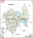
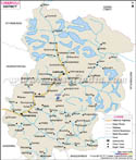
One of the most significant and geographically unique districts in the Indian state, Uttarakhand, located in Garhwal division of the central Himalayas, is the Rudraprayag district, which is among the most spiritually important districts. The district is named after the holy town of Rudraprayag, a meeting point of the Alaknanda river and the Mandakini river one of the five holy confluences which is part of the Panch Prayag. This junction place is not just a geographical phenomenon; rather a much respected holy place visited by pilgrims and travellers not only in India but also outside its borders. This significance of the region is frequently emphasized by using a Rudraprayag district map that can help perceive the mountainous landscape of it and divine paths.
The administrative centre is in the very town of Rudraprayag. The area is also commonly known to be the home of the Kedarnath temple which is among the twelve Jyotilingas of Lord Shiva and hence the district is also a major component of the Char Dham pilgrimage circuit. The rugged nature is directly reflected in the sparse population pattern because of the tough terrain that can be explained with the help of any Rudraprayag district map. This district has a very limited population, but the cultural and religious significance of this region cannot be underestimated, and the sense of spirituality, nature, and tradition is close to the identity of this place.
History
The mythological history and the history of the Garhwal region are very much connected with the historical story of the Rudraprayag district. The region used to belong to the ancient Garhwal kingdom and prior to its formal creation in 1997, it was affected by the rulers and other dynasties. The past administrative divisions of the area that is a Rudraprayag district map would indicate how it was incorporated in other neighbouring districts before it was reorganised into a separate district.
The district has a significant historical identity of mythology. The Kedarnath temple which is one of the most important temples in Hinduism is thought to have been constructed originally by the Pandavas and later restored by Adi Shankaracharya. These associations have rendered the district a perennial place of pilgrimage and such a place is generally conspicuous on any Rudraprayag district map that is carried by devotees.
In the medieval era, the region was still under the rule of Garhwal kings till the beginning part of the nineteenth century when it fell under the influence of British control following the Anglo-Nepalese war. The region became included in Uttar Pradesh and subsequently Uttarakhand following the development of the state in 2000, the year after India gained its Independence. The restructuring of the administrative structure which gave birth to Rudraprayag district in 1997 was an effort to enhance the administrative services in this remote mountainous area. This administrative development and ease of access can be seen in a modern Rudraprayag district map.
The district has also been linked with some of the most memorable events like the one concerning the notorious Leopard of Rudraprayag that haunted the area during early part of the twentieth century and was later written about by Jim Corbett. Rudraprayag with time has progressed to being far-off historical area and has become a well known pilgrimage as well as tourism destination as it is evident in the present-day Rudraprayag district map.
Culture
The culture of Rudraprayag district is a rich heritage of spirituality in combination with tradition and local practices which are deeply based on the Garhwali lifestyle. The religious importance of the district provides a powerful impact on its cultural identity as there are several temples, pilgrimage paths, and holy festivals that became the main support of the social life. TheRudraprayag district map usually shows the routes to pilgrimages in Kedarnath, Tungnath and some other shrines which play a significant role in the culture.
The celebrations in the district are also very enthusiastic and devoted. Other traditional practices like Maha Shivaratri, Makar Sankranti and even local fairs in the name of the God's of the region are full of rituals, music and dance. Kedarnath Yatra is probably one of the most important cultural and religious events and thousands of pilgrims visit the place every single year. The tracks of this pilgrimage are often followed with the help of Rudraprayag district map to find the way to overcome the difficult terrain.
Folk traditions are a significant section of everyday life in the district. The people live with a number of folk songs and dances, which are performed at any social or festive occasions and reflect the feelings, convictions, and also the way of life of Garhwali people. Conventional clothing, such as the use of woollen garments to keep off cold climate is even widely used in the rural regions. Strait forwardness and integrity of the local communities can be seen in the cultural practice of the locals that are passed through generations.
The cultural texture of the district is also comprised of handicrafts and local forms of art which are not bigger, industrially speaking. It is common to find wood examples of carvings, traditional jewellery and religious artefacts in local markets. Together, these factors present the complete picture of how geography has contributed to the shaping of culture in this part of the Himalayas after examining them along with one of the Rudraprayag district map.
Language
The language in Rudraprayag district shows the identity of the region and also its administration structure. Garhwali is the most common language that is spoken and commonly used in the district as the predominant language among the native people. Garhwali is the mother tongue of the enormous majority of the inhabitants, so it is the main language of the area, according to the Census of 2011. This can also be interpreted in the form of the linguistic overlay based on a demographic a Rudraprayag district map.
Hindi is the official language and is also extensively used as an administrative, educational, and official language. The status of an official language has also been given to the language Sanskrit in Uttarakhand state that is closely connected with the ancient traditions and religious canons of India. This language diversity brings out the fusion of the traditional and the contemporary rule in the district.
Garhwali has been largely used in conservation of the cultural heritage of the area. Folk songs, oral traditions and local storytelling, are mainly performed in the language which is making sure that the cultural knowledge is transmitted across generations. Even in isolated villages, where the indications of geographical isolation shine on the Rudraprayag district map, Garhwali is still the language of the country.
The presence of Garhwali, Hindi and Sanskrit forms a distinct linguistic environment that is the depiction of the identity of the district as a traditional region as well as a developing region. Institutions are encouraging Hindi and English, whereas local people practice their linguistic traditions by using Garhwali in their everyday life.
Geography
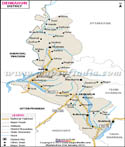
Rudraprayag district is geographically rough with Himalayan rugged topography, river valley extensive in character and high altitude topography. It is situated at about 30 ° north latitude and at 78 ° east longitude and is thus part of the Garhwal Himalayas. The topography is complicated, the steep slope, small valleys, and winding river systems dominating the area are clearly depicted in a Rudraprayag district map.
It is limited by Uttarkashi in the north, Chamoli in the east, Pauri Garhwal in the south and Tehri Garhwal in the west. The main rivers in the district are the Alaknanda and the Mandakini rivers which converge at fond Rudraprayag town to make one of the sacred knots. The Mandakini river is also derived off the Kedarnath glacier and it is another major source of emphasizing the relation of the district to the high Himalayas.
The altitude of the district is considerable, so that there are many different climatic conditions differentiated by temperate valleys and cold alpine areas. Areas in the higher regions such as the one around Kedarnath and Tungnath receive a lot of snowfall in winter and the areas further down have a relatively pleasant climate. These differences can be described in detail in a Rudraprayag district map, which is a handy item in the determination of the way elevation varies.
The geological make up of the district is also weak and the activity of the monsoons is intense and this puts the district at risk of natural hazards like landslides, floods, and cloudbursts. The 2013 devastating floods had a considerable impact on the area especially in the Mandakini valley. The strength of the place is realised in a map of the terrain of a district of Rudraprayag.
The plants in the district also vary with altitude because of the existence of the lowest altitude with the subtropical forests then there are the high altitudes of the district which have the alpine meows like Chopta which is normally called the mini Switzerland of India. The region has a diverse biodiversity comprising different fauna and flora that is adapted in the mountainous environment. In general, the Rudraprayag district map provides a significant clue to the study of the area, geography of Rudraprayag district is a key factor determining its culture, economy, and lifestyle.
| Facts of Rudraprayag District | |
|---|---|
| Official Name | Rudraprayag District |
| Population | 242,285 (As of 2011) |
| Area (km2) | 1,984 |
| Religion | Predominantly Hinduism |
| Language | Garhwali, Hindi |
FAQs
Q1: What is Rudraprayag district known for?
It is known for the Kedarnath temple and the confluence of the Alaknanda and Mandakini rivers.
Q2: When was Rudraprayag district formed?
It was established on 16 September 1997.
Q3: Which rivers meet at Rudraprayag?
The Alaknanda and Mandakini rivers meet at Rudraprayag.
Q4: Why is Rudraprayag important in Hinduism?
It is part of the Panch Prayag and a key stop on the Char Dham pilgrimage route.
Last Updated on : May 08, 2026
| Buy this Map |