
Barddhaman district - West Bengal
Barddhaman also known as Burdwan is found in the state of West Bengal. It lies to the center of the state and is the seventh most populous district in India. The place has its importance since the medieval age and also during the British rule. The soil made it very popular even at the time of Gupta period. It was known as Sharifabad and was an important administrative center.
Today it is a very important place in the state of West Bengal and is full of natural resources.
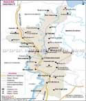
Location of Barddhaman
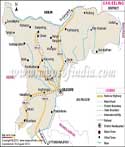
The district covers an area of 7,024 sq kms and is situated in the center. The latitude are 23 degrees 53' north and 22 degrees 56' south, the longitude are 88 degree 25' east and 86 degree 48' west. The district is surrounded by Birbhum and Murshidabad district to the north, Nadia district to the east, Hooghly district to the south east, Bankura to the south west and the state of Jharkhand to the North West.
Visitors often visit the district as it is quite an important place in the state and is an important tourists place as well. the district comprises of National Highway No. 60 which connects it to various other districts in the state and places. National highway No28 runs from the center of the district. National highway No 2 also runs from across the district and joins the NH 28 and NH 60. The major road connects various important cities and towns like Raniganj, Andak, Durgapur, Kaksa, Galsi, Memari, Jamalpur, Asansol etc. The district also has a great railway network that connects to various places. Barddhaman is a junction and is also a starting place for various trains. One branch line goes to Katwa and the other to Howrah. The head quarter is situated in Barddhaman.
Barddhaman Profile
Barddhaman district is one of the most resourceful districts of the state of West Bengal. It is quite developed in terms of agriculture and technology. The eastern part comprises of a greater part of alluvial soil due to river Bhaghirathi and is great for agriculture. The western part, Asansol is rich in coal mines and other mineral resources. It is developed industrially and there are many large industries based on steel, cement and iron. Towns like Durgapur, Kulti and Murnur are quite significant. Power plants are located in Dishergarh and Durgapur towns.
The district consists of six sub division namely the Sadar - south, Kalna, Asansol, Sadar - north, and Katwa.
| Facts of Barddhaman District | |
|---|---|
| State | West Bengal |
| District | Barddhaman |
| District HQ | Bardhaman |
| Population (2011) | 7717563 |
| Growth | 11.92% |
| Sex Ratio | 945 |
| Literacy | 76.21 |
| Area (km2) | 7024 |
| Density (/km2) | 1100 |
| Tehsils | Ausgram I, Ausgram II, Barabani, Bhatar, Burdwan I, Burdwan II, Faridpur Durgapur, Galsi I, Galsi II, Jamalpur, Jamuria, Kalna I, Kalna II, Kanksa, Katwa I, Katwa II, Ketugram I, Ketugram II, Khandaghosh, Mangolkote, Manteswar, Memari I, Memari II, Ondal, Pandabeswar, Purbasthali I, Purbasthali II, Raina I, Raina II, Raniganj, Salanpur |
| Lok Sabha Constituencies | Asansol, Bardhaman-Durgapur, Bardhaman Purba (SC), Bolpur (SC) (partly), Bishnupur (SC) |
| Assembly Constituencies | Khandaghosh, Bardhaman Dakshin, Raina, Jamalpur, Monteswar, Kalna, Memari, Bardhaman Uttar, Bhatar, Purbasthali Dakshin, Purbasthali Uttar, Katwa, Ketugram, Mangalkot, Ausgram, Galsi, Pandabeswar, Durgapur Purba, Durgapur Paschim, Raniganj, Jamuria, Asnsol Dakshin, Asansol Uttar, Kulti, Barabani |
| Languages | Bengali, Hindi |
| Rivers | Damodar, Ajay, Hoongly |
| Lat-Long | 23.483401,87.614365 |
| Travel Destinations | Tomb of Sher Afgan, Tomb of Khwaja Anwar, Goddess Kali Temple, Shah Alam Durga, Idol of Lord Siva, Siddheswari Ambika Temple, Baikunthanath Shiva Temple, Shyamarupa Temple, Temple of Tachai Ghosh, Siva temple, Radheshyam Temple, Bishnu Temple, Ranisagar, Curzon Gate, Meghnad Saha Planetarium, Deer Park, Nachan Bird Sanctuary, Maithon Dam, Sarbamangala Temple, Jima Masjid, Bardhmaneswar Siva Temple, Tomb of Syed Md. Bahaman, Gouranga Temple, 109 Siva temple, Srikhanda Temple, Tarakshya Temple, Pandalmath Temple, Kalyaneshwari Temple, Amrargarh Temple etc. |
| Government Colleges/Universities | University of Burdwan, College of Art & Design, Bishnu Goswami Arts College, Burdwan Homoeopathic Medical College, Burdwan Institute of medical and life sciences(BIMLS), Burdwan Medical College, Burdwan Raj College, Maharajadhiraj Uday Chand Women's College, University Law College, Vivekananda Mahavidyalaya, M. U. C. Women's College, Durgapur Govt. College, Katwa College etc. |