
Darjeeling District
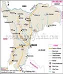
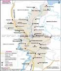
Darjeeling district lies in the north of the state of West Bengal, in the foothills of the eastern Himalayas. The district touches three international boundaries- with Nepal, Bhutan and Bangladesh. Its boundary also touches the north eastern state of Sikkim and the Jalpaiguri district of West Bengal.
Located between latitude 27° 13' N to 26° 27' N and longitude 88°53' E to 87°59' E, Darjeeling district is spread over 3149 square kilometers. The terrain in the district is both hilly and plain. The temperature ranges between 24 °C to 14°C in summer, and between 8°C to 5° C in winter. The hill areas get heavy rainfall in the monsoons. Streams and rivulets belonging to the Tista, Mahananda, Rammam, and Rangit river systems flow in the north of the district. Most of the north of the district is under tea plantations.
This district is one of the least populated districts of the state with the total population of the district 1,842,034, and the density of population 413 persons per square kilometers. As the population of the district is a mix of the Lephchas, Gorkhas, Bhutias, Bengalis, many languages are spoken here. The main languages are Hindi, Bengali, Nepali, Gorkha, English and Tibetan.
Main Towns
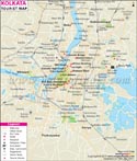
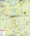
The entire district has four subdivisions- Darjeeling (Sadar), Kalimpong, Kurseong, and Siliguri. Darjeeling town, the headquarters of the district, is at an altitude of 6710 feet. Kalimpong, Kurseong, and Siliguri are other main towns and sub divisional headquarters. Siliguri is the largest town and one of the most densely populated cities and industrial towns of the state. Kalimpong, Darjeeling, Kurseong are popular hill stations.
The other towns in Darjeeling subdivision are Pulbazar, Rangli Rangliot and Sukhlapokhari. Towns in Kalimpong subdivision are Kalimpong and Gurubathan. The towns in Kurseong division are Kurseong and Mirik, and the towns in Siliguri subdivision are Matigara, Naxalbari, Kharibari, Batasi, Baghdogra and Phansidewa.
Road and Railway Connection
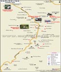
Roads are very important for connectivity within district and to reach the upper hill areas. The district has a network of several main connector roads and national highways which pass through. Darjeeling district is connected to West Bengal and the rest of the country by National Highway 31, National Highway 31C, and National Highway 55. Siliguri, strategically located in the plains, is an important transit town for the upper regions of the district, and for Sikkim and other north eastern states.
The district has a narrow gauge rail line passing through Darjeeling town. The Himalayan Darjeeling railway connecting Siliguri to Darjeeling is a World heritage site and a tourist attraction in the district. The railway station at Ghum town is the highest in the country. The closest broad gauge line is in the neighboring district of New Jalpaiguri. Darjeeling district has an airport at Bagdogra, the only airport in the region.
| Facts of Darjiling District | |
|---|---|
| State | West Bengal |
| District | Darjiling |
| District HQ | Darjeeling |
| Population (2011) | 1846823 |
| Growth | 14.77% |
| Sex Ratio | 970 |
| Literacy | 79.56 |
| Area (km2) | 3149 |
| Density (/km2) | 585 |
| Tehsils | Darjeeling Pulbazar, Gorubathan, Jorebunglow Sukiapokhri, Kalimpong I, Kalimpong II, Kharibari, Kurseong, Matigara, Mirik, Naxalbari, Phansidewa, Rangli Rangliot |
| Lok Sabha Constituencies | Darjeeling |
| Assembly Constituencies | Kalimpong, Darjeeling, Kurseong, Matigara-Naxalbari, Siliguri, Phansidewa |
| Languages | English, Gorkha, Bengali, Hindi |
| Rivers | Tista, Great Rangit, Mechi, Balason, Mahananda, Lish, Gish, Chel,Ramman, Murti, Jaldhaka |
| Lat-Long | 26.926968,88.362236 |
| Travel Destinations | Tiger Hill, Batasia Loop, War Memorial, Ava Art Gallery, Rock Garden, Ganga Maya Park, Peace Pagoda, Botanical Garden, Nightingale Park/Srubbery Park, Darjeeling-Rangit Valley Passenger Cable Car, Senchal Lake, Mahakal Temple, Dhirdham Temple, Happy Valley Tea Garden, Padmaja Naidu Himalayan Zoological Park, Raj Bhawan, Druk Thupten Sangag Choling Monastery, Ghoom Monastery , Tashi Dargyalingh Monastery, The Mag-Dhog Yolmowa Buddhist Monastery, Eagle's Crag, Netaji Subash Chandra Bose Museum, Thongsha Gumpa, Tharpa Choling Monastery, Mangal Dham, Zong Dong Palri Fo-Brang Monastery, Pedong Monastry, Kawlay Dara, Deosi Dara, Rai-dhap, Singha Devi Mandir etc. |
| Government Colleges/Universities | Darjeeling Government College, Loreto College, St Joseph's College, Bijanbari College, Gyan Jyoti College, Ghoom-Jorebunglow Degree College, Kalimpong College, Kurseong College, Kalipada Ghosh Tarai Mahavidyalaya, Mirik College, University of North Bengal, North Bengal Medical College, Salesian College, Siliguri College, Surya Sen Mahavidyalaya, Sonada Degree College, Southfield College etc. |