
Puruliya district - West Bengal
Puruliya district lies to the west of West Bengal and is famous for its hills of Ajodha and Baghmundi falls. It has found a place of significance due to its tropical location. The location of Puruliya is very convenient as it is well connected to various parts of other states in the country and to the industrial belt of West Bengal.
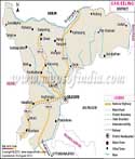
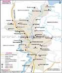
Location of Purulia
Purulia is located between 22.60 degrees and 23.50 degrees north latitudes and 85.75 degrees and 86.65 degrees east longitudes. The total area covered is 6259 sq.kms. Purulia is surrounded by Bankura and Paschim Medinipur districts to the east. In the north is Bradhama district and Jharkahnd state. To the west is Jharkhand state and to the south is Bihar and Paschim Medinipur. To the east lies Bankura district. The district is close to the Kasai River.
The map here provides detail information regarding the other towns and cities that connect to various other places and are of great significance. The district comprises of a National Highway No. 32 and No. 60A and is a major road and railway junction as well. The map will show you exactly where the major roads are and which places they run through. Some of the major cities are Arsha, Jhalida, Jaipur, Hura, Puncha, Balarampur, Bara Bhum, Kashipur and many more. The district has a good roadway network that becomes convenient for transport. The district head quarter is in Puruliya city. Due to its proximity to the state of Orissa, people from Purulia find it convenient to travel to the state and is also the reason for its development as well. Purulia is easily accessible by road and by rail from any part of the country. The nearest major city is Kolkata that is to the west of the district.
Purulia profile
The district has a population of around 2,927,965 according to 2011 report. Out of which, 90 percent are residing in rural areas and 10.07 in urban areas. The male population was 1,497,656 and female population was 1,430,309. The total literacy found in the district is 65 percent. The male literacy rate is 79 percent and female is 52 percent. There are around 955 girls per 1000 boys.
Tourism in Purulia
Tourism flourishes in Purulia. Visitors here often find interesting places to visit like the temples in Deulghera, the terracotta sculptures and the waterfalls, hills and dams that comprise of natural beauty are a major attraction here.
| Facts of Puruliya District | |
|---|---|
| State | West Bengal |
| District | Puruliya |
| District HQ | Purulia |
| Population (2011) | 2930115 |
| Growth | 15.52% |
| Sex Ratio | 957 |
| Literacy | 64.48 |
| Area (km2) | 6259 |
| Density (/km2) | 468 |
| Tehsils | Arsha, Bagmundi, Balarampur, Barabazar, Bundwan, Hura, Jaipur, Jhalda I, Jhalda II, Kashipur, Manbazar I, Manbazar II, Neturia, Para, Puncha, Purulia I, Purulia II, Raghunathpur I, Raghunathpur II, Santuri |
| Lok Sabha Constituencies | Purulia, Bankura, Jhargram |
| Assembly Constituencies | Bandwan, Balarampur, Baghmundi, Joypur, Purulia, Manbazar, Kashipur, Para, Raghunathpur |
| Languages | Bengali, Hindi, English |
| Rivers | Kangsabati, Kumari, silabati (silai), Dwarakeswar, Subarnarekha, Damodar |
| Lat-Long | 23.261534,86.493759 |
| Travel Destinations | Joychandi Pahar, Ayodhya Hill, Para, Saheb Bandh, Cheliama, Deulghat etc. |
| Government Colleges/Universities | Achhruram Memorial College, Ananda Marg College, Balarampur College, Bengal Institute of Science & Technology, Jagannath Kishore College, Mahatma Gandhi College, Manbhum Mahavidyalaya, Kashipur Michael Madhusudan Mahavidyalaya, Netaji Subhas Ashram Mahavidyalaya, Nistarini College, Panchakot Mahavidyalaya, Purulia Homoeopathic Medical College & Hospital, Raghunathpur College, Ramananda Centenary College, Sponsored Teachers' Training College etc. |