Cyclone Lehar weakens into a well marked low pressure area over Andhra Pradesh |
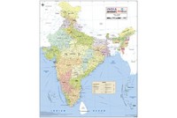
Cyclone Lehar Track Map
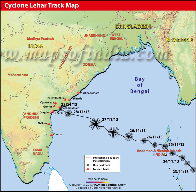
Map showing the expected path of Cyclone Lehar.
Andhra Pradesh relieved as Cyclone Lehar weakens
Cyclone Lehar Live Updates
29-11-2013, 9:30 am:
Depression over the coastal parts of Andhra Pradesh and Telangana weakened further into a well marked low pressure area at around 11:30 pm, yesterday. These regions and Yanam district of Puducherry would experience light to moderate rainfall today.
28-11-2013, 2:45 Pm:
Cyclone Lehar Track and Intensity Forecast
| Date | Time | Position (Lat. °N/Long. °E) | Max. sustained surface wind speed (kmph) | Cyclone Intensity |
|---|---|---|---|---|
| 28/11/13 | 11:30:00 AM | 15.7/81.3 | 55-65 gusting to 75 | Deep depression |
| 28/11/13 | 05:30:00 PM | 16.0/80.3 | 50-60 gusting to 70 | Deep depression |
| 28/11/13 | 11:30:00 PM | 16.3/79.3 | 35-45 gusting to 55 | Depression |
Source: IMD
28-11-2013, 11:30 am:
Cyclone Lehar now is centred about 80 km from Machillipatanam. Naveen Patnaik, CM of Odisha, ordered officials to deploy Odisha Disaster Rapid Action Force (ODRAF) in sensitive areas of the state.
28-11-2013, 9:00 am:
Cyclone Lehar weakens into a deep depression and moved west-northwest at 20 kmph. Though it is expected to weaken further by today afternoon, the government is continuing with its safety and precautionary measures. Most parts of the coastal regions of Andhra Pradesh and Puducherry’s Yanam district are likely to receive isolated heavy to very heavy rainfall today. The cyclone may cause damage to unsecured and weak structures.
27-11-2013, 10:30 pm:
The ‘very severe’ Cyclone Lehar weakened into a ‘severe’ cyclonic storm and centred itself over west-central Bay of Bengal.
27-11-2013, 5:30 pm:
Cyclone Lehar moves over west-central and south of Bay of Bengal and is about 520 km east south-east of Machillipatnam. It is expected to move in west northwest direction and would gradually get weak as it will cross Machillipatnam.
27-11-2013, 4:30 pm:
Government of Andhra Pradesh and Odisha have asked the coastal districts’ collectors to be on high alert. Educational institutions and small shops are closed for today and and tomorrow. Andhra Pradesh government will be deploying 30 teams of National Disaster Response Force (NDRF) in the coastal regions for relief and rescue operations. 15 out of these 30 teams are already working in the districts of Visakhapatnam, East and West Godavari and Krishna district. Special officers have been appointed for the cause in nine coastal districts of India. A plan to evacuate 2.5 lakh people in Andhra Pradesh is in progress.
Security measures from all aspects are being taken into account. The Union Defence Secretary has been requested to position four helicopters for emergency help at Vishakhapatnam. Marine Police, Coastal Security Wing, Coast Guard, and districts’ Superintendents of Police, are all on high alert.
N Kiran Kumar Reddy, CM of Andhra Pradesh and Chief Secretary PK Mohanty discussed about all possible measures to prevent any loss of live. Even a newly formed State Disaster Response Force (SDRF) comprising 450 personnel including firemen, policemen, etc. is being deployed for rescue operations. Siddharth Jain, the district collector of West Godavari District, stated, “One NDRF team will be in Eluru while the other three teams will be stationed in those areas of the district which are likely to be hit by the cyclone.” He also added that 30 villages have been shifted to relief areas.
27-11-2013, 2:30 pm:
As predicted by the Joint Typhoon Warning Center (JTWC), cyclone Lehar’s wind speed will reach around 175 kmph today. And by the time the cyclone hits the coastal regions of India, the wind speed would decrease to about 158 kmph.
27-11-2013, 12:10 pm:
Wind speed would intensify to 65 kmph along and off Andhra Pradesh today evening. At the time of the landfall, the gale wind speed is expected to reach 150-160 kmph gusting to 170 kmph along and off the Yanam district of Puducherry and Guntur, Krishna, West Godavari, East Godavari and Vishakhapatnam districts of Andhra Pradesh.
27-11-2013, 10:30 am:
The weather bureau reports that the cyclone moved west northwestwards with a speed of 15 kmph over west-central and nearby southern parts of Bay of Bengal. It is also forecasted to cause rainfall over coastal regions of Odisha, Andhra Pradesh and Yanam district of Puducherry, today. The rainfall is expected to intensify from heavy to very heavy downpours on 28th November. Also, the coastal areas of Andhra Pradesh and Telengana would experience isolated heavy to very heavy rainfall on 29th November, as per the report by India Meteorological Department (IMD).
Emergency Numbers for Cyclone Lehar
Control Room Numbers
Secretariat – (040) 23452144, 23451043
27-11-2013, 9:20 am:
Today, Cyclone Lehar centred itself over south east and adjoining central Bay of Bengal around 760 km from Machillipatnam. The cyclonic storm is expected to intensify and thereby cause severe damage and destruction to kutcha houses in the coastal regions of Andhra Pradesh and Odisha, agricultural crops, and even disruption of rail and road traffic, when it hits the two states on 28th Nov 2013.
26-11-2013, 5:40 pm:
The cyclonic storm moved with a speed of 16 kmph towards west north-west over south-east and west central Bay of Bengal and is about 430 km west north-west of Port Blair and 920 km east south-east of Machillipatnam.
26-11-2013, 2:30 pm:
Weather bureau reports that the cyclone has intensified and is now a very severe cyclonic storm centred around 360 km west north-west of Port Blair.
26-11-2013, 2:00 pm:
Cyclone Lehar moved westwards at a speed of 15 kmph and centred over south-east bay of Bengal, about 300 km west north-west of Port Blair, 900 km south-east of Kalingapatnam, 970 km east-southeast of Kakinada and 1030 km east south-east of Machillipatnam.
Precautionary measures as suggested by the Indian Meteorological Department for Andhra Pradesh and Odisha
- Fishing operations suspended and fishermen advised to return back
- Evacuation of coastal areas to be mobilised and people presently in the affected areas advised to remain indoors
- Rail and road traffic to be regularized
25-11-2013, 2:15 pm:
Considering the intensity of the cyclone, Odisha government has asked fishermen to return to safer places, especially in the ports of Gopalpur and Paradip. Also, Bubaneshwar Met Office asked the state’s government to take preventive measures to save standing crops in southern part of Odisha from destruction.
25-11-2013, 2:01 pm:
Four flights for Port Blair from Chennai were cancelled due to unpleasant weather conditions in Andaman and Nicobar islands. Also, hundreds of people were evacuated after the severe cyclonic storm had hit the region with a wind speed of 110 kmph, yesterday.
25-11-2013, 10:35 am:
There seems to be no respite from cyclones for the Bay of Bengal. Just as the region is battling with the fearsome Cyclone Helen, another storm is building up in the South Andaman Sea and is likely to hit Andhra Pradesh within 3-4 days. Termed Cyclone Lehar, this windstorm has already crossed Port Blair and is heading towards the northern regions of Andhra Pradesh. That means its area of attack will the same as that of Cyclone Phailin.
But perhaps the worst news for the state is that Cyclone Lehar will be much more destructive than its predecessor. Gale winds of speed more than 150 km/hr are expected to blow, whereas for Cyclone Helen these were just above 100 km/hr. This Category III cyclone is expected to stay in the Bay of Bengal for a couple of days and gain in strength before it heads off to make landfall.