Alluri Sitharama Raju District Map


District Map of Alluri Sitharama Raju

separator Click here for Customized Maps arrow custom map
District Map of Alluri Sitharama Raju
Print Email Save Buy Now 
*Alluri Sitharama Raju District Map highlights the National Highway, Major Roads, District Headquarter, etc in Alluri Sitharama Raju. Disclaimer
  Major Districts of Andhra Pradesh  
Anantpur District Map Guntur District Map East Godavari District Map Chittoor District Map
Anantpur District MapGuntur District MapEast Godavari District MapChittoor District Map
    
Prakasam District Map Krishna District Map Kurnool District Map Vishakhapatnam District Map
Prakasam District MapKrishna District MapKurnool District MapVishakhapatnam District Map
 
  Other Districts of Andhra Pradesh >>

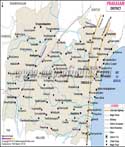
One of Andhra Pradesh's north-eastern districts, Alluri Sitharama Raju District is located between 17° 17′ and 18° 21′ North Latitude and between 80° 53′ and 82° 50′ Eastern Longitude. Its northern border is partially formed by the state of Odisha. bounded on the south front by the districts of Anakapalli, East Godavari, and Kakinada, on the western front by the Godavari River; and on the eastern front by the district of Vijayanagaram.

There is a clear geographic split in the District. It comprises the hilly Eastern Ghats area with an elevation of roughly 900 metres and some peaks that rise over 1200 metres.


Last Updated on : December 26, 2022