


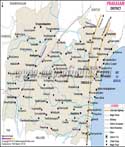


Eluru district was created in 2022 from a portion of the former West Godavari District and eight former Krishna District mandals, totalling 27 mandals and three revenue units. Its headquarters are located at ELURU.
The Eluru District's demographic, climatic, topographic, and other socioeconomic elements are described in further depth below. The District has a size of 6411.56 square kilometres and a density of 312 inhabitants per square kilometre. It makes up 3.9% of the State's overall area. The district has up to 655 Revenue villages, of which 624 are inhabited and the remaining 31 are vacant. In the district, there are 550 Gram Panchayats altogether.
Last Updated on : November 13, 2025