Wayanad District Map |
|
|||||||||||

|
|||||||||||
|
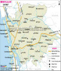
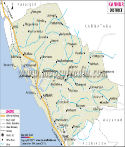
| *Map showing national highway, major roads, district headquarter, etc in Wayanad District of Kerala. | Disclaimer |
| Major Districts of Kerala |
 |
 |
 |
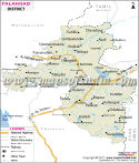 |
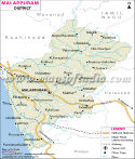
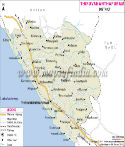
| Ernakulam District Map | Malappuram District Map | Kollam District Map | Palakkad District Map |
 |
 |
 |
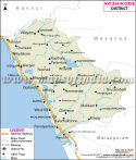 |
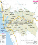
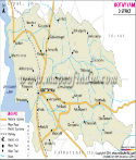
| Kannur District Map | Thiruvananthapuram District Map | Kottayam District Map | Kozhikode District Map |
| other districts of Kerala >> |
The geographical location of Wayanad is 11. 27' to 15. 58' north latitude and 75. 47' to 70. 27' east longitude. The total area of Wayanad is 2132 sq km. As per the census carried in 2001, the total population of the district is 780,619. The population density being 369 people per km.
Agriculture is the main source of economy in Wayanad. Tea, coffee, rubber are the main plantation crops. Other than these paddy, different vegetables and fruits are also grown.
Important Tourist Places of Wayanad
Chembra Peak
Kuruva Island
Lakkidi
Pakshipathalam
Kanthanpara Waterfalls
Pazhassi Raja Tomb
Places in Wayanad Map
Tholpattyvaval, Vemon, Periya, Mukkie, Koroth, Maananthavaadi, Tindummal, Kartikulam, Pulpalli, Kuppathod, Penamaram, Kaniyambetta, Tariyod, Kalpetta, Chundale, Vayittiri, Lakkadi, Meppadi, Kottapadi, Ambalavayal, Nenmeni, Sultan bathery, Ottapalam
Last Updated on : November 13, 2025
|
|