|
||||||||||||
 | ||||||||||||
|
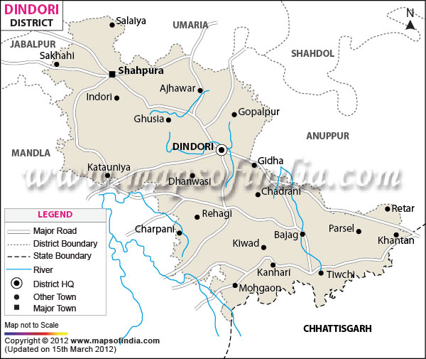
| *Dindori District Map highlights the National Highways, Major Roads, District Headquarter, etc in Dindori. | Disclaimer |
The district of Dindori encompasses a total area of 571883 hectares. The district is part of the Jabalpur division of Mahakausal region.
Dindori district holds a total population of 579312 , in which 290572 are men and 288740 are women. The district comprises of 97 % rural and tribal population.
The district draws its revenue from agricultural and forest products. Dindori has not yet experienced industrialization. The district is one of the most economically backward regions of the state due to absence of proper infrastructure and modern amenities.
Last Updated on : January 23, 2015
Dindori district holds a total population of 579312 , in which 290572 are men and 288740 are women. The district comprises of 97 % rural and tribal population.
The district draws its revenue from agricultural and forest products. Dindori has not yet experienced industrialization. The district is one of the most economically backward regions of the state due to absence of proper infrastructure and modern amenities.
| Facts of Dindori District | |
|---|---|
| State | Madhya Pradesh |
| District | Dindori |
| District HQ | Dindori |
| Population (2011) | 704524 |
| Growth | 21.32% |
| Sex Ratio | 1002 |
| Literacy | 63.9 |
| Area (km2) | 7427 |
| Density (/km2) | 94 |
| Tehsils | Dindori, Shahpura, Mehandwani, Amarpur, Bajag, Karanjiya, Samnapur |
| Lok Sabha Constituencies | Mandla |
| Assembly Constituencies | Shahpur (ST), Dindori (ST) |
| Languages | Bagheli, Hindi, Chhattsgarhi |
| Rivers | Narmada, Silgi |
| Lat-Long | 22.852133,81.083794 |
| Travel Destinations | National Fossil Park, Kukarramath, Shiv Temple, Kapildhara Art Emporium, Kapildhara Waterfall, Dagona Waterfall, Devnala Caves etc. |
| Government Colleges/Universities | Govt Chandravijay College, Govt Degree College (Shahpura) etc. |
Last Updated on : January 23, 2015
|
|