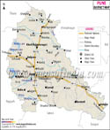
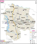
Gondia District is situated in the western Indian state of Maharashtra. It was created out of the Bhandara district. It is located in the north-eastern part of the state and is bordered by the states of and Madhya Pradesh. Gondia District Map is useful to people embarking on travel to Gondia .
The headquarters of the district is Gondia town, which is located on the Mumbai- Kolkata railway route. The state capital, Mumbai is 1060 kilometers from here. Nagpur is 130 kilometers by rail and 170 kilometers by road. There are road links to the districts of Bhandara and Chandrapur as well.
The district is surrounded by Balaghat district of Madhya Pradesh in the north and Rajnandgaon district of Chhattisgarh in the east. The Bhandara district and Chandrapur district of Maharashtra are to the west and south.
Gondia District is divided into two subdivisions - Deori and Gondia. Each of these subdivisions has 556 Grampanchayat, 4 talukas and 954 revenue villages.