


Economy
Meghalaya's economy mainly depends on agriculture, mining, tourism. The different kinds of soils include red-loamy, as well as laterite soils, which are ideal for several crops such as rice, maize, pulses, oilseeds, cotton, and jute. It has also made rapid progress in the cultivation of non-traditional crops like tea, cashew nuts, oilseeds, tomato, mushroom, and so on. It produces high-quality turmeric as well.
The state has mining deposits in abundance like coal, limestone, kaolin feldspar, quartz, granite, industrial clay and uranium, and many more.
The tourism sector has brought a hefty amount of money to the state. Meghalaya is a paradise for tourists. It has several national parks, wildlife sanctuaries, hill stations to entice the visitors. Apart from this, tourists get an opportunity to enjoy adventure sports like mountaineering, rock climbing, hiking and trekking, water sports, and so on. The British nicknamed the state "Scotland of the East" The total number of tourists visited in Meghalaya was 1,216,454 in 2018.
Gross State Domestic Product (GSDP) of Meghalaya touched Rs 0.93 trillion (US$ 5.47 billion) in 2019-20.
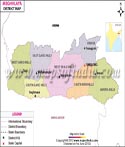
Meghalaya has 11 districts, divided into three divisions, which are as follows:
Khasi Hills Division:
- East Khasi Hills (Shillong)
- West Khasi Hills (Nongstoin)
- South West Khasi Hills (Mawkyrwat)
- Ri-Bhoi (Nongpoh)
Garo Hills Division:
- North Garo Hills (Resubelpara)
- East Garo Hills (Williamnagar)
- South Garo Hills (Baghmara)
- West Garo Hills (Tura)
- South West Garo Hills (Ampati)
Jaintia Hills Division
- West Jaintia Hills (Jowai)
- East Jaintia Hills (Khliehriat)
Shillong is the capital of Meghalaya, known as a popular hill station. There are several falls in and around Shillong. The Shillong peak is the highest in the state and is ideal for trekking. It is also known as the 'abode of the gods' and has excellent views. If one is not in a mood for camping, the state also offers many good hotels and lodging facilities.
Meghalaya also boasts of its village Mawlynnong, declared the cleanest village in Asia. The Discovery India Magazine awarded the prestigious tag of 'Cleanest Village in Asia' in 2003 to this village.
Over the years, this state has become a hotspot for tourists. People from the country as well as abroad visit the state every year. The natural beauty of the state is something worth seeing, and the fresh air and weather are worth experiencing in this state.
Some of the national highways in Meghalaya are National Highway 40, National Highway 44, National Highway 51, and others.
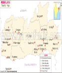
Major Towns of Meghalaya
- Shillong
- Cherrapunjee
- Tura
- Nongpoh
- Nongstoin
- Mairang
- Mankachar
Some of the Tourist Attractions in Meghalaya
- Seven Sisters Falls (Cherrapunjee)
- Umiam Lake (Shillong)
- Don Bosco Centre for Indigenous Cultures (Shillong)
- Double Decker Living Root Bridge (Cherrapunjee)
- Double Decker Living Root Bridge (Cherrapunjee)
Best Time to Visit
There are only two seasons in this state, Monsoon, and Winter. If you do not like getting drenched in the rain, then you should plan your trip during the winter season.
How to Reach
Meghalaya has a good bus service. Meghalaya Transport Department (MTC) has been providing interstate and across the state bus services.
The state has only one civilian airport known as Umroi Airport, which is around 40 km away from Shillong.
Currently, Meghalaya is connecting by rail network. The 19.75 km long Dudhnoi to Mendipathar railway line was inaugurated by prime minister Narendra Modi in 2014. Its 9.75 km track falls in Assam and 10 km in Meghalaya.
Meghalaya State Information | |
|---|---|
| Capital | Shillong |
| Date of formation | 21 January 1972 |
| Governor | Shri C H Vijayashankar |
| Chief Minister | Conrad Sangma |
| Tourist attractions | Cherrapunji Garo Hills, Tura, Butterfly Museum, Central Museum |
| Festivals | Wangala (Harvest Festival), Shad Nongkrem |
| Major dance and music forms | Shad Sukmynsiem, Shad Nongkrem and Doregata dances |
| Arts and crafts | Endi silk is used to make colourful wraps and hawls; baskets known as khokd thugis are commonly woven; cone shaped bamboo rain shields known as knup are also popular. |
| Languages | Khasi, Garo, Jaintia, Bengali, Assamese, English |
| Size | 22,429 sq. km |
| Population (Census 2011) | 2964007 |
| Rivers | Simsang,Myntdu. Digaru, and so on |
| Forests and wildlife sanctuaries | Nokrek NP, Balpakram NP, Nongkhyllem WS, Nokrek Biosphere Reserve, Siju Bird Sanctuary |
| State animal | Clouded leopard |
| State bird | Hill myna |
| State flower | Lady slipper orchid |
| State tree | Gamhar |
| Major crops | Potato, cotton, pineapple, orange |
| Factoids | Nartiang in Jaintia Hills has a cluster of megaliths and monoliths. |
| Garos celebrate a good harvest with Wangala, or the dance of Hundred Drums, in November. | |
| No. of District | 11 |
MOI.AB.27.01.17
All Civil Services Examination aspirants out there! Learn more about the Indian geography on our resource- oriented platform, Maps of India.
Last Updated on : February 21, 2025