| Click any neighbouring District / State and get the Detailed District Map |
 |
District Map of Firozabad |
|
 |
|
 |
|
|
|
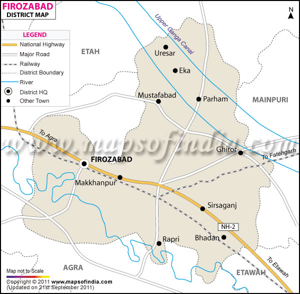
*The Map showing the National Highway, Major roads, other Roads, District Headquarter, Town, etc in the Firozabad District, Uttar Pradesh |
Disclaimer
|
Close Disclaimer: All efforts have been made to make this image accurate. However Mapping Digiworld Pvt Ltd and its directors do not own any responsibility for the correctness or authenticity of the same. |
Firozabad is situated in the western part of
Uttar Pradesh. It encompasses an area of 2362sq.km. as registered in the 2011 census. The total population of the district is 2496761.
This district has a long history of glass industries and the major products are glass hard ware, glass artware, glass domestic ware, glass automobile ware, chandelier, glass street and domestic light ware etc.
Firozabad has been attached to the Indian Freedom Movement and occupies an important place in the map of India.
| Facts of Firozabad District |
|---|
| State | Uttar Pradesh |
| District | Firozabad |
| District HQ | Firozabad |
| Population (2011) | 2498156 |
| Growth | 21.69% |
| Sex Ratio | 875 |
| Literacy | 71.92 |
| Area (km2) | 2361 |
| Density (/km2) | 1044 |
| Tehsils | Firozabad, Jasrana, Shikohabad, Tundla |
| Lok Sabha Constituencies | Firozabad |
| Assembly Constituencies | Firozabad, Jasrana, Shikohabad, Sirsaganj, Tundla |
| Languages | Hindi, Urdu |
| Rivers | Yamuna |
| Lat-Long | 27.186242,78.562431 |
| Travel Destinations | Chadamilal Jain Temple, Shri Shuparshnath Jain Mandir, Gher Khokal, Chandprabhu Jain Mandir, The Jama Masjid, Marsalganj Jain Temple, The Kalan Mosque etc. |
| Government Colleges/Universities | Shri P.D. Jain Inter College, S.R.K. College Of Computer Science & Education etc. |
Last Updated on : December 10, 2014
