Geography (Class 12) Term 2 Question Paper 2023
1. Who, among the following economists created the Human Development Index in the year 1990?
(A) Prof. Amartya Sen
(C) Dr. Mahbub-ul-Haq
(B) Dr. Manmohan Singh
(D) Ellen C. Semple
2. Which one of the following approaches was initially proposed by the International Labour Organisation (ILO)?
(A) Income Approach
(B) Welfare Approach
(C) Basic Needs Approach
(D) Capability Approach
3. Which of the following is NOT a key area in human development?
(A) Access to resources
(B) Long and healthy life
(C) Education
(D) Economic disadvantage
4. In a developed economy, the majority of workers got employment in which of the following sectors of the economy?
(A) Primary sector
(C) Tertiary sector
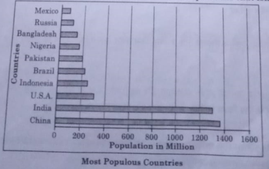
(B) Secondary sector
(D) Quaternary sector
5. Which one of the following activities is related to quaternary activities?
(A) Production of information
(B) Fishing
(C) Tourism
(D) Trading
6. Which one of the following is NOT a characteristic of retail trading?
(A) It is concerned with selling goods directly to the consumers.
(B) Most of the retail trading takes place in fixed establishments.
(C) Most of the retail stores procure their supplies from intermediate stores.
(D) Retail trading constitutes bulk business through numerous intermediary merchants and supply houses.
7. Modern manufacturing is NOT characterised by which one of the following?
(A) A complex machine technology (B) Vast capital
(C) Small organisations
(D) Executive bureaucracy
8. Identify the feature of mixed farming from the following:
(A) It is most advanced and efficient type of rearing milch animals.
(B) Equal emphasis is laid on crop cultivation and animal husbandry
(C) It was introduced by the Europeans in colonies.
(D) The regions where farmers specialised in vegetables only.
9. Which of the following is an example of an ‘educational town’?
(A) Surat
(B) Delhi
(C) Pilani
(D) Jaipur
10. Which one of the following is NOT true about Bharmaur tribal region?
(A) This region comprises of Bharmaur and Holi tehsil of Chamba district.
(B) It is not a notified tribal area.
(C) It is mainly inhabited by Gaddi tribal community.
(D) The tribals practise transhumance.
11. Which of the following statement is NOT true regarding Indira Gandhi Canal?
(A) It was previously known as Rajasthan canal.
(B) It originates at Harika barrage in Punjab.
(C) The canal runs almost parallel to Pakistan border.
(D) Rajasthan is least benefitted by this canal.
12. Which of the following commission replaced Planning Commission?
(A) Election Commission
(B) NITI Aayog
(C) Law Commission
(D) Education Commission
13. Choose the correct pair from the following :
(A) Industrial town – Vishakhapatnam
(B) Transport town – Satna
(C) Commercial town – Bhilai
(D) Administrative town – Bhopal
14. Match the Column I with Column Il and choose the correct option:
| Column I | Column II |
| i Clustered | a. Isolated settlement |
| ii Semi-clustered | b. Units are locally known as Panna, Para, Palli |
| iii Hamleted | c. Fragmented settlement |
| iv Dispersed | d. Closely built up region |
Options:
(A) i-a, ii-b, iii-c, iv-d
(B) i-d, ii-c, ini-b, iv-a
(C) i-b, ii-a, iii-c, iv-d
(D) i-c, ti-b, ii-a, iv-d
Read the following source and anewer the question no. 16 to 17.
A Case Study
Jhabun district is located in the westernmost agro-climatic Madhya Pradesh. It is, in fact, one of the five most backward distra the country. It is characterized by high concentration of tribal popu (mostly Bhils). The people suffer due to poverty which has accentuated by the high rate of resource degradation, both forest land, The watershed management programmes funded by both Ministries of “Rural Development” and “Agriculture”, Government India, have been successfully implemented in Jhabua district which gone a long way in preventing land degradation and improvin quality. Watershed Management Programmes acknowledge the between land, water and vegetation and attempts to improve Livelbood of people through natural resource management and comm participation. In the past five years the programmes funded by Ministry of Rural Development alone (implemented by Rajiv Gam Mission for Watershed Management) has treated 20 percent of the area under Jhabua district.
The Petlawad Development block of Jhabua is located in the nord part of the district and represents an interesting and successful Government-NGO partnership and community participation in mans watershed programmes. The Bhils in Petlawad Development example, (Sat Rundi hamlet of Karravat village) through thei efforts, have revitalized large parts of common property resource household planted and maintained one tree on the pogmon propes They also have planted fodder grass on the pasture land and ado social-fencing of these lands for at least two years. Even after thai say, there would be no open grazing on these lands, but stall cattle, and they are thus confident that the pastures they have develo would sustain their cattle in future.
An interesting aspect of this experience is that before the community embarked upon the process of management of the pasture, there was encroachment on this land by a villager from an adjoining village. The villagers called the tehsildar to ascertain the rights of the common land.
The ensuing conflict was tackled by the villagers by offering to make the defaulter encroaching on the CPR a member of their user group and sharing the benefits of greening the common lands / pastures.
15. Why did the people of Jhabua tribal community suffer from poverty?
Choose the option which is NOT correct.
(A) High rate 6f forests degradation
(B) Land degradation
(C) Illiteracy
(D) Implementation of watershed management
16. How did people manage to develop pasture lands? Choose the correct option.
(A) Use of barbed wire to protect pastures.
(B) Pasture lands were not under any encroachment.
(C) Pastures were common property resources, hence they developed it.
(D) Govt. officials did not interfere in any work of the villagers.
17. How did the Bhils, through their own efforts revitalise the common property resources? Choose the correct option.
(A) Common land was brought under cultivation.
(B) They controlled open grazing on the common property resources.
(C) No tree plantation was taken up.
(D) They developed water resources.
18. Read the given source and answer the questions that follow:
We use many items in our daily life. From toothpaste to our bed tea, milk, clothes, soaps, food items, etc., are required everyday. All these can be purchased from the market. Have you ever thought as to how these items are brought from the site of production? All the production is meant for consumption. From the fields and factory, the produce is brought to the place from where consumers purchase it. It is the transportation of these items from the site of their production to the market which make them available to the consumer.
We not only use material things, like fruits, vegetables, books, clothes, etc., but also use ideas, views and messages in our daily life. Do you know we exchange our views, ideas and messages from one place to another or one individual to another while communicating with the help of various means?
The use of transport and communication depends upon our need to move things from place of their availability to the place of their use.
Human beings use various methods to move goods, commodities, ideas from one place to another.
(18.1) Explain the utility of transportation.
(18.2) Define the term ‘Communication’.
(18.3) Differentiate between transport and communication.
19. Study the given figure carefully and answer the questions that follow :