Geography (Class 12) Term 2 Question Paper 2024
SECTION-A (Q. Nos. 1 to 17 are Multiple Choice Questions)-
Neeru-Meeru watershed management program is associated with which of the following states?
2. Which of the following is a means of mass awareness regarding water conservation?
(A) Writing letters to the people. (B) Telephone conversation (C) Through T.V. and Print Media (D) Personal contact with pe3. Which one of the following is the main objective of Jal Kranti Abhiyan?
(A) Per capita water availability assurance (B) Hain water harvesting to (C) Conservation of water resources (D) Providing sufficient water for agriculture4. Two statements are given below. They are Assertion (A) and Reason (R). Read them carefully and choose the correct option. Assertion (A) : *Free international trade can prove to be detrimental to the underdeveloped countries." Reason (R): Underdeveloped countries are not at pur to compete with developed countries.
Options: (A) (A) is correct, but (R) is incorrect. (B) (A) is incorrect, but (R) is correct. (C) Both (A) and (R) are correct and (R) is the correct explanation of (A). (D) Both (A) and (R) are correct, but (K) is not the correct explanation of (A).5. Which of the following fact, about jute cultivation in India, is true?
(A) West Bengal is the leading producer of jute. (B) Jute is a cash crop for Punjab and Haryana. (C) Madhya Pradesh and Maharashtra are other leading jute-producing Etatea. (D) India produces about 30% of the jute production in the world.6. Read the following information carefully and identify the correct option for the crap :
|
7. Which one of the following states in India le the leading producer of Manganese?
(A) Jharkhand (B) Odisha (C) Madhya Pradesh (D) Bihar8. Which one of the following is the largest coalfields in India?
(A) Jharin (B) Raniganj (C) Neyveli (D) Bakaro9. Which of the following waterways and their stretches are correctly matched?
| (National Waterways) | Stretch |
| (A) National Waterways No. 1 | Godavari - Krishna |
| (A) National Waterways No. 2 | Sadiya - Dhubri |
| (A) National Waterways No. 3 | Allahabad - Haldia |
| (A) National Waterways No. 4 | Kottapuram - Kollam |
10. Match the Column-I with Column lI and choose the correct option :
| Column- I (Railway Zone) | Column-II (Headquarters) |
| (A) Northern | (i) Hajipur |
| (B) South Central | (ii) Chennai |
| (C) Southern | (iii) New Delhi |
| (D) East Central | (iv) Secundrabad |
| (a) | (b) | (c) | (d) | |
| (A) | (iv) | (iii) | (ii) | (i) |
| (B) | (iii) | (iv) | (ii) | (i) |
| (C) | (i) | (ii) | (iii) | (iv) |
| (D) | (ii) | (iii) | (iv) | (i) |
11. Which of the following metro-cities is not linked with the 'Golden Quadrilateral'?
(A) Mumbai (B) Chennai (C) Hyderabad (D) Delhi12. The statements are given below, They are Assertion (A) and Reason Read them carefully and choose the correct option.
Assertion (A): "The gateways of the International trade are the ports and harbors." Reason (R): Only heavy cargos are transported through ports and harbors in the world.
Options : (A) (A) is correct, but (R) is incorrect, (B) (A) is incorrect, but (R) is correct. (C) Both (A) and (R) are correct and (R) is the correct explanation of (A). (D) Both (A) and (R) are correct, but (R) is not the correct explanation of (A).13. Which one of the following is an example of an oil port?
(A) Abadan (B) Manchester (C) Kochchi (D) Dover14. Two statements are given below. They are Assertion (A) and Reason (R). Read them carefully and choose the correct option.
Assertion (A): "Waterway is an important mode of transport both for passengers and cargo traffic in India." Reason (R); "It is fuel efficient and eco-friendly mode of transport."
Options: (A) Both (A) and (R) are correct and (R) is the correct explanation of (A). (B) Both (A and (K) are correct, but (It) la not the correct explanation of (A). (c) (A) is correct, but (R) is incorrect. (D) (A) is incorrect, but (R) is correct Read the given passage and answer the Question Nos. 15 to 17 Characteristics of High Human Development The high level of human development group has 53 countries, Providing education and healthcare is an important government priority. Countries with higher human development are those where a lot of investment in the social sector has taken place, Altogether, a higher investment in people and good governance has set this group of countries apart from the others. Many of these countries have been the former imperial powers. The degree of social diversity in these countries is not very high. Many of the countries with a high human development score are located in Europe and represent the industrialized Western world. Yet there are striking numbers of non-European countries also who have made it to this list.15. Which one of the following is an important priority of high human development index countries? Choose the most appropriate option.
(A) Education and healthcare (B) Healthcare and territorial security (C) Education and industrial development. (D) Economic development and per capita income16. Which one of the following differentiates the higher human development countries from others? Choose the most appropriate option.
(A) Higher gross domestic production (B) Higher investment in the social sector (C) Higher industrialization (D) Higher per capita income17. How many countries are under a high human development index category? Choose the correct option.
(A) 51 (B) 52 (C) 53 (D) 54 SECTION - B Nos. 18 and 19 are Source Based Questions.) Read the given passage carefully and answer the questions that follow : Integrated Tribal Development Project in Bharmaur Region This region lies between 32° 11' and 32° 41' N latitudes and 76' 22' E and 76° 58 E longitudes. Spread over an area of about 1,818 sq km, the region mostly lies between 1:500 m to 3,700 m above the mean sea level. This region popularly known as the homeland of Gaddis is surrounded by lofty mountains on all sides. It has Pir Panjal in the north and Dhaula Dhar in the South. In the east, the extension of Dhula Dhar converges with Pir Panjal near Rohtang Pass. The river Ravi and its tributaries the Budhil and the fundalen, drain this territory and carve out deep gorges. These rivers divide the region into four physiographic divisions called Holi, Khani, Kugti and Tundah areas. Bharmaur experiences freezing weather conditions and snowfall in winter. Its mean monthly temperature in January remains 4 "C and in July 26 °C.(18.1) Describe the location of the Bharmaur region. (18.2) Why does this region experience harsh climatic conditions? Give one геsson. (18.3) Why is this region economically backward? Explain any one reason.
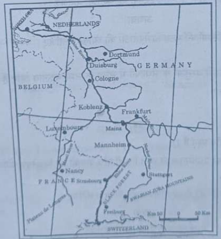
9. Study the given map carefully and answer the questions that follow :
Inland Waterway