Clickable World Map!

Clickable World Map Canada Map Map of Alaska (USA) USA Map United Kingdom Map Australia Map China Map Russia (Russian Federation) Map Russia Map France Map France New Caledonia (France) San Marino Map Italy Map Italy Switzerland Mexico Iceland Belize Guatemala El Salvador Honduras Nicaragua Jamaica Map Costa Rica Panama Bermuda (UK) Cuba Bahamas Haiti Dominican Republic Hawaii (usa) Kiribati Tonga French Polynesia Venezuela Colombia Ecuador Galapagos (Ecuador) Peru Guyana Surinam French Guiana Bolivia Chile Easter Island (Chile) Paraguay Argentina Uruguay Brazil Falkland Islands Norway Sweden Finland Faroe Islands Denmark Ireland Estonia Latvia Lithuania Russia (Russian Federation) Belarus Poland Ukraine Moldova Germany Netherlands Belgium Czech Republic Luxembourg Switzerland Liechtenstein Austria Slovenia Croatia Bosnia Herzegovina Slovakia Hungary Romania Bulgaria Serbia Montenegro Albania Macedonia Greece Republic of Cyprus Turkey Spain Portugal Georgia Armenia Syria Iraq Jordan Israel Azerbaijan Kuwait Saudi Arabia Qatar Yemen Oman United Arab Emirates Egypt Libya Tunisia Algeria Morocco Western Sahara Mauritania The Gambia Senegal Guinea Bissau Guinea Sierra Leon Liberia Mali Burkina Faso Cote D'ivorie Ghana Togo Benin Niger Nigeria Chad Cameroon Central African Republic Gabon Republic Of Congo Democratic Republic Of Congo Angola Sudan South Sudan Uganda Rwanda Burundi Eritrea Djibouti Ethiopia Somalia Kenya Tanzania Zambia Mozambique Sao Tome and Principe Malawi Namibia Zimbabwe Botswana eswatini Lesotho South Africa Madagascar Jan Mayen (Norway) Svalbard (Norway) Iran Turkmenistan Uzbekistan Kyrgyzstan Tajikistan Afghanistan Pakistan India Nepal Bhutan Bangladesh Sri Lanka Kazakhstan Mongolia North Korea South Korea Japan Taiwan Philippines Vietnam Cambodia Laos Thailand Myanmar Brunei Malaysia Malaysia Timor Leste Papua New Guinea Indonesia Indonesia Indonesia Newzealand Fiji Solomon Islands Marshall Islands Andaman and Nicobar Islands Maldives Seychelles Mauritius Greenland Netherlands Map Belgium Map Luxembourg Map Switzerland Map Slovenia Map Croatia Map Bosnia and Herzegovina Map Czech Republic Map Slovakia Map Australia Map Hungary Map Serbia Map Moldova Map Macedonia Map Albania Map Cyprus Map Lebanon Map Guinea Bissau Map Guinea Map Ghana Map Togo Map Benin Map Cameroon Map Equatorial Guinea Map Rwanda Map Cambodia Map Panama Map Malawi Map Liechtenstein Map Montenegro Map Kosovo Map Palestine Map Antarctica Map Antarctica Map Map of Cook Islands South Georgia South Sandwich Northern Mariana Islands Guam Map Federated States Of Micronesia Zip Codes Kiribati Map Map of St Vincent and the Grenadines Puerto Rico Saint Kitts and Nevis Antigua and Barbada Dominica Saint Lucia Barbados Trinidad And Tobago Saint Helena Cocos Islands Map Christmas Island Map Reunion map Wallis and Futuna Nauru Map Map of Vanuatu Samoa Map Tonga Map Map of Palau
Print Email Save Tweet this map  


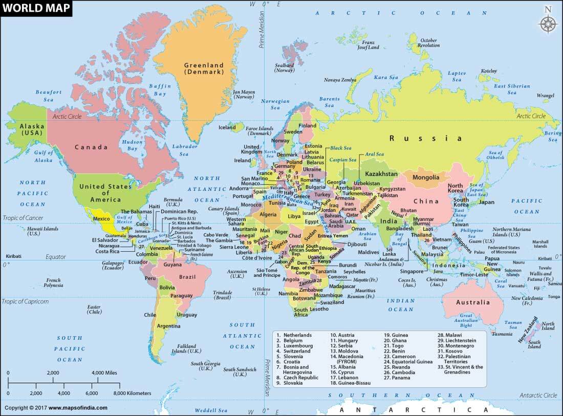
This political world map depicts all the countries with their administrative boundaries. The countries have been shown in bright colours, to facilitate easier distinguishing of one country from another. Our world is divided into not just geographical boundaries, but political divisions as well. This system helps in asserting laws and peace around the world. Political maps help people understand specific boundaries, and understand the geographical location of important places in the world.

In the map above, if you click on a country in the world map illustrated, you will be directed to another page with a description of the country, supported with its particular map. The three dimensional world that we are intrigued by, can be easily understood on a two dimensional world map. Our expert team of cartographers has created the map after a thorough research on boundary demarcations. In only one glance, we can understand where and how far a specific country is, in comparison to our own. The United Nations has identified 195 countries in the world, and the political world map specifies territorial borders of each.

The integration of clickable world maps has brought significant change to the way people engage themselves with geographical data and other forms of graphical information. These maps can be accessed through the web, tablets, computers, or other digital devices and offer innovative ways to teach geography or population issues of the world today. Whether used in schools to help teach about different countries or continents, or used by travelers to plan their trip around the world, clickable world maps are an easily accessible tool. One can now simply click on the areas of interest and gain more specific content, zoom in and out, and even configure the map based on their wish. Technological progress has ensured that clickable world map are perceived as an essential Web tool in various fields and industries.

It can be useful in the educational setting these maps are perhaps the most useful applications among the current technological enhancements in communication. These maps provide multi-functional geography, history, and cultural lessons for the student in an easily understandable manner. Through using clickable map, teachers can develop interesting lessons through which the learners can click on different parts of the globe to access information. Maps have emerged as essential tools to use for travelers and tourism industries. They are a strong source for traveling as they map out the different places and traveling options. Many travel sites and applications can pinpoint clickable maps that allow users to find different objects, such as attractions, lodging, and transportation.

Clickable maps can provide valuable information to improve the conclusions that a business may make about the market in which they are present. Through the use of a graphical representation of sales figures, customer profiles, and regional results organizations can see where they are best placed to expand and where they are lacking in their goals. The clickable maps are able to provide regional bias and therefore the business can apply the bias to the successful marketing strategies and customer satisfaction.

These maps are flexible and can be used as instruments for geopolitical analysis and research. They enable analysis and research to represent large datasets and observe the evolving dynamics and relations between countries or nations. It made use of the maps where one can add the interactivity for political boundaries, conflict regions, and trade regions among others which helps in understanding the static as well as the kinetic world.

World Map on Different Themes


FAQs


Q.1. What is a clickable world map, and how does it work?

Ans. A clickable world map is an interactive digital map that allows users to click on specific countries, regions, or locations to access additional information, links, or features. These maps use HTML, JavaScript, or Flash technology to create a responsive and engaging experience. By clicking on a country or region, users can view details such as capital cities, population, language, or cultural information.


Q.2. What are the educational applications of clickable world map?

Ans. Clickable world maps serve as powerful educational tools, enhancing teaching and learning in geography, history, cultural studies, and related disciplines. Interactive maps facilitate engagement, improve knowledge retention, and develop critical thinking skills. Educators can create custom maps integrating multimedia content, quizzes, or games to create immersive learning experiences.


Q.3. Can clickable world maps be used for commercial purposes?

Ans. Yes, clickable world maps can be used for commercial purposes, such as advertising, marketing, or e-commerce. Businesses can integrate clickable maps into their websites or applications to showcase products, services, or locations. However, ensure compliance with licensing requirements, copyright laws, and data protection regulations.


Q.4. What are the benefits of using a clickable world map?

Ans. Clickable world maps offer numerous benefits, including enhanced user engagement, improved navigation, and streamlined access to information. These maps facilitate exploration, learning, and research, making them ideal for educational institutions, research organizations, and businesses.


Last Updated on: February 28, 2025