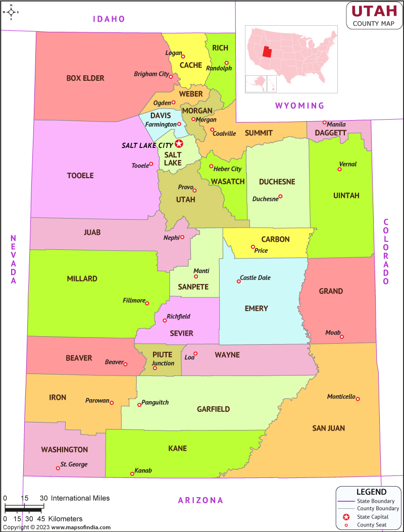
Utha is a state situated in the western portion of the country, surrounded by Arizona to the southern front, Idaho to the northern front, Colorado to the eastern front, Wyoming to the northeastern front, and Nevada to the western front. It is known for its unique geography, including mountains, deserts, and salt flats. Utha is also home to several national parks and monuments, including Zion National Park and Bryce Canyon National Park.
History
Utha was originally inhabited by various Native American tribes, including the Ute, Paiute, Goshute, and Navajo. In 1847, Mormon pioneers led by Brigham Young settled in the Salt Lake Valley and established the state's capital, Salt Lake City. The Mormons played a significant role in shaping Utha's history, culture, and economy.
In the late 19th century, Utha's economy expanded with the discovery of silver, gold, and copper. This led to an influx of settlers and the establishment of several mining towns. Utha also played a role in the Transcontinental Railroad, with the completion of the First Transcontinental Railroad at Promontory Summit in 1869.
Culture
Texas has a rich and diverse culture that is heavily influenced by its Spanish, Mexican, and Native American roots. The state is known for its cowboy culture, which includes rodeos, country music, and Western fashion. The cuisine of Texas is also heavily influenced by its Mexican and Spanish heritage, and it is known for dishes such as Tex-Mex, chili con carne, and barbecue.Utha's culture is influenced by the state's history and geography. The dominant religion in Utha is Mormonism, which is reflected in the state's conservative values and family-oriented culture. The state also has a strong outdoor culture, with many residents participating in outdoor activities such as skiing, hiking, and camping. Utha is known for its unique cuisine, including fry sauce, funeral potatoes, and Jell-O salad.
Language
English is the most commonly spoken language in Utha, but Spanish is also widely spoken, especially in the southern part of the state. Utha also has a significant population of speakers of Native American languages, such as Ute and Navajo.
Geography
Utha has a diverse geography, with a mix of mountains, deserts, and valleys. The state's highest point is Kings Peak, which stands at 13,534 feet. The Great Salt Lake, the largest saltwater lake in the Western Hemisphere, is also located in Utha. Utha is home to several national parks and monuments, including Zion National Park, Bryce Canyon National Park, and Arches National Park.
| Official Name | Utah |
| Capital | Salt Lake City |
| Area | 219,662 km2 |
| Population | 32.7 Lakh |
| Language | English |
| Religion | Christianity |
| Admitted to the Union | January 04, 1896 |
FAQs
Q1: What is the population of Utah?
The population of the state is over 3.2 million people. The majority of the population lives in urban areas, with the largest cities being Salt Lake City and Provo.
Q2: What is the capital of Utah?
The capital city is Salt Lake City. It is the most populous city in the state and is known for its scenic beauty, outdoor recreation, and cultural attractions.
Q3: What is Utah's state symbol?
Utah has several state symbols, including a state bird (California gull), a state flower (sego lily), and a state tree (quaking aspen). The state also has a state emblem, which features a beehive, a symbol of hard work and industry.
Q4: What is the geography of Utah like?
The state is home to several prominent mountain ranges, including the Wasatch Range and the Uinta Mountains.
Last Updated on: February 10, 2025
