
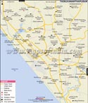
Geography:
Ernakulam district has an area of 895 sq. km, and an altitude of 300 m, and can be divided geographically into highland, midland, and coastal area. Ernakulam district is bordered by the Arabian Sea in the west, Thrissur District in the north, Idukki District in the east, and Alappuzha and Kottayam districts in the south. The Periyar River, which is Kerala's second longest, flows through all the taluks except Muvattupuzha. The Muvattupuzha River and a branch of Chalakkudy River also flow through the district. The district has an optimum climate, and mostly lies within the Malabar Coast moist forests ecoregion, while the highlands are part of the South Western Ghats moist deciduous forests ecoregion.
Statistical Figures:
- Area: 2407 sq.km
- Population: 3,105,798 (in 2001)
- Language: Malayalam and English
- Religion: Hindu, Christian, Muslim, Jains, Sufi, Jews, Sikhs
- Average Rainfall(Annually): 3432 mm
- Temperature: 23-32 degree Celsius
Festivals:
- Sivarathri: It is celebrated at the Siva Temple of Aluva and attracts people from all across the country.
- Christian Pilgrim Center Festival: The famous Christian Pilgrim Center at Malayttoor is located in Ernakulam district, where the annual festival in April lasts for 10 days.
- St. George Church Festival: It is located in Kadamattam, and was founded by Mar Abo Metropolitan in 5th Century A.D. A cross was brought from Persia, which is still preserved in the church. The cross attracts numerous pilgrims every year to visit the place.
Education:
Ernakulam has a significant place among the districts of Kerala in the domain of literacy and educational standards. Ernakulam District is the first district throughout the country to have achieved 100 percent literacy by 1990.
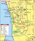
Ernakulam Facts
| City Name | Ernakulam |
| State | Kerala |
| District | Ernakulam |
| District Headquarters | Kakkanad |
| Tehsil/Taluk | Kochi |
| Lat Long | 9.980509, 76.297659 |
| Area | 3,032 km2 (1,171 sq mi) |
| Population as per 2011 | 3,282,388 (District Population) |
| Official Languages | Malayalam, English |
| Time zone | IST (UTC+5:30) |
| STD Code | 0484 |
| Transport | Air, Road, Rail |
| Vehicle registration | KL-07 |
| Food and Cuisine | Coconut Dominates, Rice and Curry, Vegetarians Non-Vegetarians, Fish, Seafood, Staple Foods, Nendranga Chips, Chilli, Cumin, Dill Seed, Fennel, Fenugreek and Garlic are important Spices. |
| Religion | Hinduism, Muslim and Christianity |
| Festival | Onam and Vishu, Holi , Christmas, Easter, Eid ul-Fitr, Milad-e-sherif, Cochin Carnival etc. |
| Monuments | St Francis Church, Fort Kochi, Chottanikara Temple, Ernakulathapan Temple, Hanuman Temple, Muruga Temple, CSI Church, |
| Places of interest | Marine Drive, Chinese Fishing Nets, Hill Palace Museum, Bolgatty Island, Willington Island, Kodanad, Dutch Palace, Chendamangalam, Bhoothathankettu, St. Thomas Syro-Malabar Catholic Church, Malayattoor, Ernakulam Town Hall |
| Hotels | The Gateway Hotel, Marine Drive, Grand Hotel, The International Hotel, Hotel Aiswarya, Avenue Regent, Travancore Court, Presidency Hotel, Excellency Hotel, Yuvarani Residency, The Gateway Hotel Marine Drive Ernakulam etc. |
| Markets | Ernakulam Market, Supplyco Sabari Super Market etc. |
| Industries | Green Carton Industries, Prima Agro Limited, Khadi Gramodyog Bhawan, Lakssmi Enginnring Industries, St. George Industries, Rajana Wood Industries, Josco Food Industries, etc. |
| University/College | Sikkim Manipal University, Government Law College, School of Marine Science, Maharajas College, Government Model Engineering College, St.Teresas Women's College, Govt. St.Alberts College, Sacred Heart College etc. |
| Notable people | Sahodaran Ayyappan, K Francis George - Politician, Johnny Nellore - Politician, T. M. Jacob - Politician, Jose Thettayil - Politician etc. |
Last Updated on: May 11, 2026