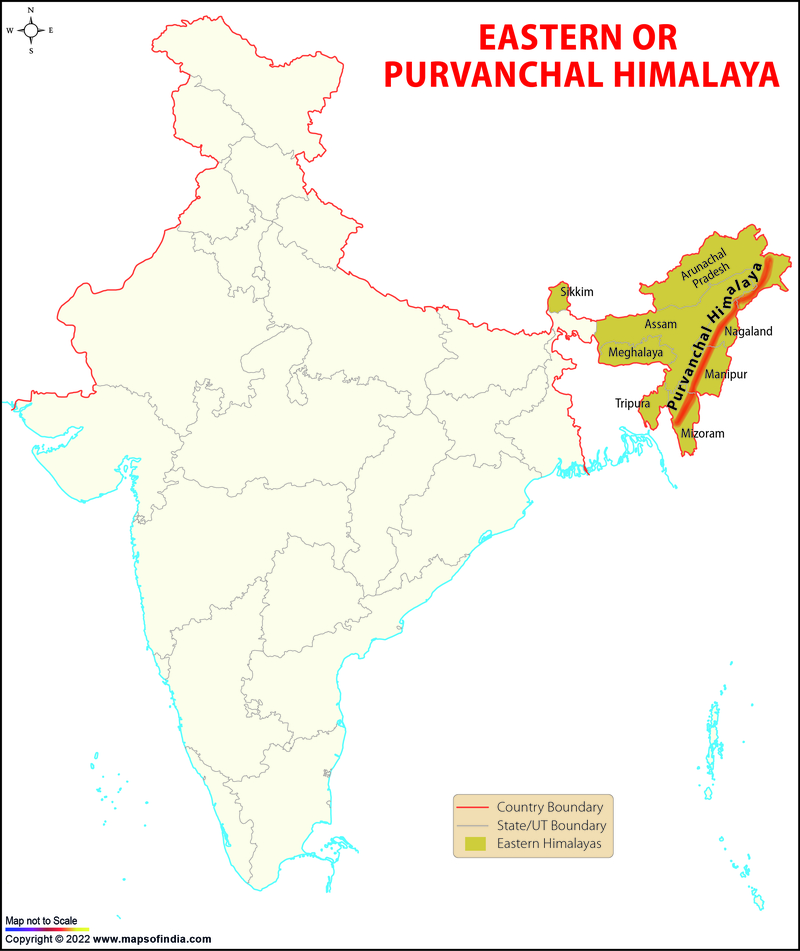
After the Dihang Gorge, the Himalayas turn towards the south and accumulate in the eastern boundary of India. This part of the Himalayas is called 'Eastern or Purvanchal Hills'.
Dafla, Abor, Mishmi, Patkai Boom, Naga, Manipur, Garo, Khasi, Jaintia, and Mizo hills are part of the hills Eastern Himalayas.
Here are the significant hills of the Eastern Himalayas:
- Dafla Hills
These hills are located north of Tezpur and North Lakhimpur and are surrounded by Aka hills in the west and Abor hills in the east. - Abor Hills
These hills are located in the far north-east of India in Arunachal Pradesh near the border of China and India. Mishmi and Miri hills are situated on the border of these hills. The Dibang river flows in this region, a tributary of the Brahmaputra. - Mishmi Hills
These hills are found along with the southern extension of the Himalayas. Their eastern and northern regions touch the border of China. - Patkai Bum Hills
These hills extend along the border of India and Myanmar and are formed by tectonic activities in the Mesozoic era during the origin of the Himalayas. Like the Himalayas, steep slopes, sharp peaks, and deep valleys are found here. - Naga Hills
These hills form the border of India and Myanmar. The extension of these hills is found in the state of Nagaland in India. - Manipur Hills
These hills are mainly found in the state of Manipur and are surrounded by the states of Assam in the west (Mizoram in the south, the country of Myanmar in the east, and Nagaland in the north). - Mizo Hills
The Mizo Hills are located in the south-eastern state of Mizoram. These giant hills are also known as 'Lushai Hills'. The Mizo hills form the northern part of the Arakan Yoma system. - Tripura Hills
The Tripura hills are located in the state of Tripura. It is a series of parallel folds from north to south, whose height decreases towards the south, and eventually, the Ganges-Brahmaputra joins the lowlands. - Mikir Hills
These hills are located to the south of the Kaziranga National Park in Assam and are a part of the Karbi-Anglong plateau. Dhansiri and Jamuna rivers flow in this region. - Garo Hills
The Garo hills are located in the state of Meghalaya, these ridges are considered one of the wettest places on earth. Nokrek Peak is known as the highest peak of Garo Hills. - Khasi Hills
The Khasi Hills are situated in the state of Meghalaya, these hills are named after the Khasi tribe, who live in this region. Cherrapunji, which is the rainiest place in the world, is located in the East Khasi Hills. The Lum-Shillong is known as the highest peak of Khasi Hills. - Jaintia Hills
These are mainly located to the east of the Garo Hills in the state of Meghalaya. - National Science Museums in India
- Jyotirlinga Shrines
- Geological Map of India
- Canals in India
- Major Lakes in India
- Heritage Map of India
- Pin Code Zones in India
- Per Capita Income of India
- Major Sea Ports
- Languages in India
- Climate map of India
- Parlimentary Constituencies in India
- Tourist Circuits in India
- Metallic Minerals in India
- Cold Desert Map
- Major Electricity Generator Plants
- Religions In India
- Major Earthquakes in India
- Major Hydro Power Plants
- Indian States and Union Territories
- Cabinet Ministers
- Map of Indian States and Union Territories Enlarged View
- Physiographic Map of India
- Religious Places in India
- Geographical Map of India
- Dams in India
- India Coal Reserves Map
- India Political Map Enlarged View
- India Satellite Map
- Topographic Map of India
- Population Map Of India
- Natural Hazard Map of India
- Tourist Map of India Enlarged View
- Tier I and Tier II Cities of India
- Cyclone Prone Areas in India
- Outline Map of India Enlarged View
- Wine Producing Regions in India
- Map of Major Airports in India
- Birth Rate in India
- Statehood Movements in India
Geographical Maps
India: Rivers Drainage Network
Agriculture Maps of India
India Climate Maps
Mineral Wealth of India
Soil & Vegetation of India
General Maps
Last Updated on: August 24, 2022

